You are here: Home > Network List > TA - USArray Transportable Network (new EarthScope stations) Stations List
> Station C35A Jirik Farms, Max, MN, USA > Earthquake Result Viewer
C35A Jirik Farms, Max, MN, USA - Earthquake Result Viewer
| Earthquake location: |
Northern Chile |
| Earthquake latitude/longitude: |
-18.0/-69.4 |
| Earthquake time(UTC): |
2011/03/06 (065) 12:31:59 GMT |
| Earthquake Depth: |
118 km |
| Earthquake Magnitude: |
6.0 MB, 6.3 MW, 6.3 MW |
| Earthquake Catalog/Contributor: |
WHDF/NEIC |
|
| Network: |
TA USArray Transportable Network (new EarthScope stations) |
| Station: |
C35A Jirik Farms, Max, MN, USA |
| Lat/Lon: |
47.70 N/93.98 W |
| Elevation: |
426 m |
|
| Distance: |
69.0 deg |
| Az: |
342.467 deg |
| Baz: |
154.888 deg |
| Ray Param: |
0.05559707 |
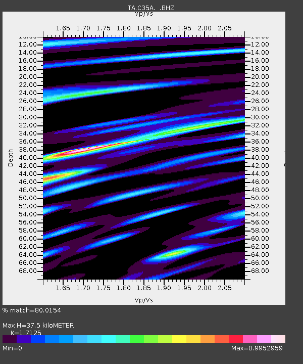
| Estimated Moho Depth: |
37.5 km |
| Estimated Crust Vp/Vs: |
1.71 |
| Assumed Crust Vp: |
6.571 km/s |
| Estimated Crust Vs: |
3.837 km/s |
| Estimated Crust Poisson's Ratio: |
0.24 |
|
| Radial Match: |
80.0154 % |
| Radial Bump: |
400 |
| Transverse Match: |
66.20887 % |
| Transverse Bump: |
400 |
| SOD ConfigId: |
354511 |
| Insert Time: |
2011-08-09 08:32:43.641 +0000 |
| GWidth: |
2.5 |
| Max Bumps: |
400 |
| Tol: |
0.001 |
|

Signal To Noise
| Channel | StoN | STA | LTA |
| TA:C35A: :BHZ:20110306T12:42:21.92502Z | 7.9029946 | 5.8147623E-7 | 7.357669E-8 |
| TA:C35A: :BHN:20110306T12:42:21.92502Z | 4.190279 | 3.5211835E-7 | 8.40322E-8 |
| TA:C35A: :BHE:20110306T12:42:21.92502Z | 2.6686304 | 2.9306875E-7 | 1.09819915E-7 |
| Arrivals |
| Ps | 4.2 SECOND |
| PpPs | 15 SECOND |
| PsPs/PpSs | 19 SECOND |


