You are here: Home > Network List > TA - USArray Transportable Network (new EarthScope stations) Stations List
> Station X39A Fountain Ranch, Mena, AR, USA > Earthquake Result Viewer
X39A Fountain Ranch, Mena, AR, USA - Earthquake Result Viewer
| Earthquake location: |
Northern Chile |
| Earthquake latitude/longitude: |
-18.0/-69.4 |
| Earthquake time(UTC): |
2011/03/06 (065) 12:31:59 GMT |
| Earthquake Depth: |
118 km |
| Earthquake Magnitude: |
6.0 MB, 6.3 MW, 6.3 MW |
| Earthquake Catalog/Contributor: |
WHDF/NEIC |
|
| Network: |
TA USArray Transportable Network (new EarthScope stations) |
| Station: |
X39A Fountain Ranch, Mena, AR, USA |
| Lat/Lon: |
34.51 N/94.11 W |
| Elevation: |
326 m |
|
| Distance: |
57.3 deg |
| Az: |
335.742 deg |
| Baz: |
151.744 deg |
| Ray Param: |
0.06322448 |
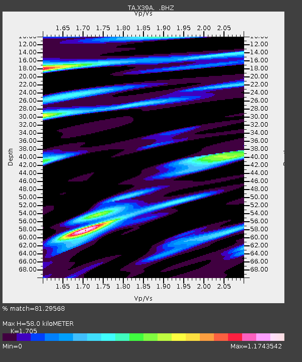
| Estimated Moho Depth: |
58.0 km |
| Estimated Crust Vp/Vs: |
1.71 |
| Assumed Crust Vp: |
6.498 km/s |
| Estimated Crust Vs: |
3.811 km/s |
| Estimated Crust Poisson's Ratio: |
0.24 |
|
| Radial Match: |
81.29568 % |
| Radial Bump: |
400 |
| Transverse Match: |
75.33851 % |
| Transverse Bump: |
400 |
| SOD ConfigId: |
354511 |
| Insert Time: |
2011-08-09 08:50:59.324 +0000 |
| GWidth: |
2.5 |
| Max Bumps: |
400 |
| Tol: |
0.001 |
|
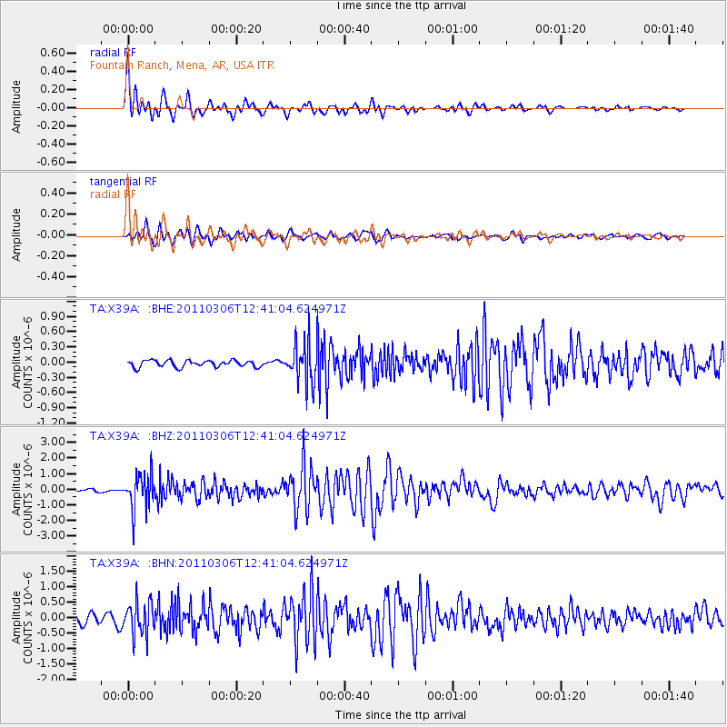
Signal To Noise
| Channel | StoN | STA | LTA |
| TA:X39A: :BHZ:20110306T12:41:04.624971Z | 8.238568 | 1.1425954E-6 | 1.3868858E-7 |
| TA:X39A: :BHN:20110306T12:41:04.624971Z | 3.5646753 | 5.392047E-7 | 1.5126334E-7 |
| TA:X39A: :BHE:20110306T12:41:04.624971Z | 6.147685 | 4.0259818E-7 | 6.548777E-8 |
| Arrivals |
| Ps | 6.6 SECOND |
| PpPs | 23 SECOND |
| PsPs/PpSs | 30 SECOND |


