You are here: Home > Network List > US - United States National Seismic Network Stations List
> Station HAWA Hanford, Washington, USA > Earthquake Result Viewer
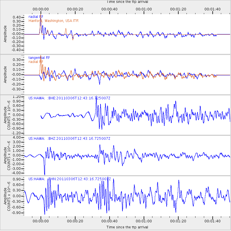
HAWA Hanford, Washington, USA - Earthquake Result Viewer
*The percent match for this event was below the threshold and hence no stack was calculated.
| Earthquake location: |
Northern Chile |
| Earthquake latitude/longitude: |
-18.0/-69.4 |
| Earthquake time(UTC): |
2011/03/06 (065) 12:31:59 GMT |
| Earthquake Depth: |
118 km |
| Earthquake Magnitude: |
6.0 MB, 6.3 MW, 6.3 MW |
| Earthquake Catalog/Contributor: |
WHDF/NEIC |
|
| Network: |
US United States National Seismic Network |
| Station: |
HAWA Hanford, Washington, USA |
| Lat/Lon: |
46.39 N/119.53 W |
| Elevation: |
364 m |
|
| Distance: |
78.5 deg |
| Az: |
327.147 deg |
| Baz: |
131.772 deg |
| Ray Param: |
$rayparam |
*The percent match for this event was below the threshold and hence was not used in the summary stack. |
|
| Radial Match: |
66.49111 % |
| Radial Bump: |
400 |
| Transverse Match: |
74.86019 % |
| Transverse Bump: |
400 |
| SOD ConfigId: |
354511 |
| Insert Time: |
2011-08-09 09:04:00.517 +0000 |
| GWidth: |
2.5 |
| Max Bumps: |
400 |
| Tol: |
0.001 |
|
Signal To Noise
| Channel | StoN | STA | LTA |
| US:HAWA: :BHZ:20110306T12:43:16.725007Z | 9.234782 | 1.2706893E-6 | 1.3759818E-7 |
| US:HAWA: :BHN:20110306T12:43:16.725007Z | 2.491805 | 4.1134624E-7 | 1.6507963E-7 |
| US:HAWA: :BHE:20110306T12:43:16.725007Z | 6.1174994 | 4.946006E-7 | 8.0850135E-8 |
| Arrivals |
| Ps | |
| PpPs | |
| PsPs/PpSs | |


