You are here: Home > Network List > TA - USArray Transportable Network (new EarthScope stations) Stations List
> Station 435B Jarrell, TX, USA > Earthquake Result Viewer
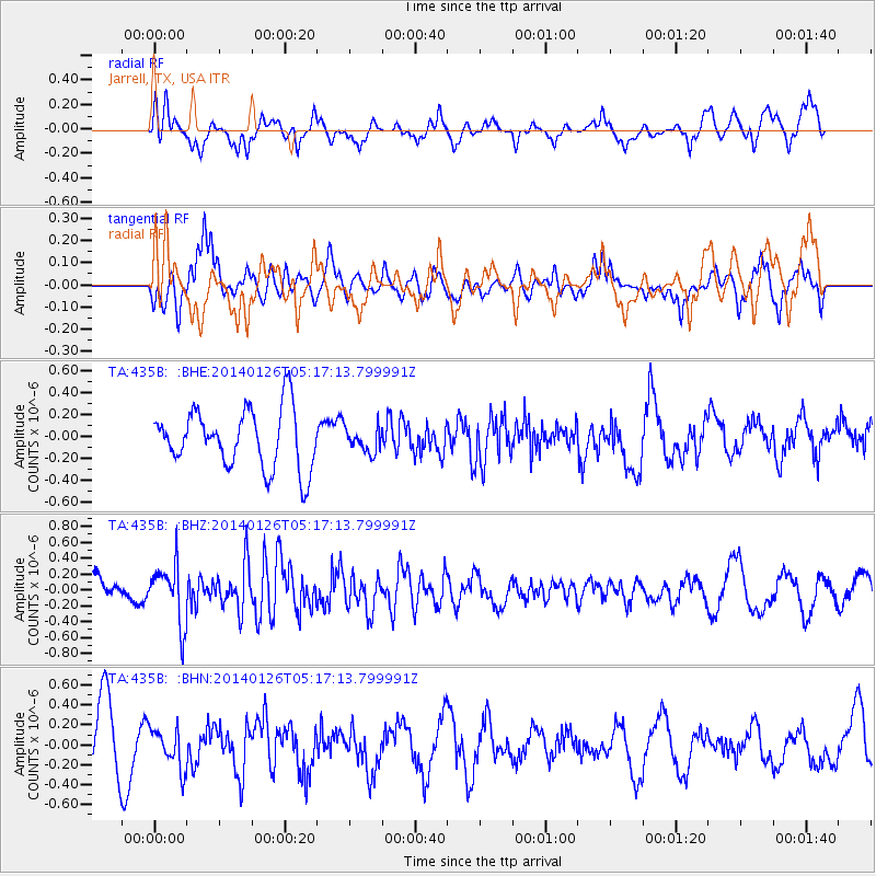
435B Jarrell, TX, USA - Earthquake Result Viewer
*The percent match for this event was below the threshold and hence no stack was calculated.
| Earthquake location: |
Peru-Ecuador Border Region |
| Earthquake latitude/longitude: |
-3.8/-80.9 |
| Earthquake time(UTC): |
2014/01/26 (026) 05:10:28 GMT |
| Earthquake Depth: |
20 km |
| Earthquake Magnitude: |
5.3 MW |
| Earthquake Catalog/Contributor: |
ISC/ISC |
|
| Network: |
TA USArray Transportable Network (new EarthScope stations) |
| Station: |
435B Jarrell, TX, USA |
| Lat/Lon: |
30.78 N/97.58 W |
| Elevation: |
248 m |
|
| Distance: |
37.9 deg |
| Az: |
336.252 deg |
| Baz: |
152.166 deg |
| Ray Param: |
$rayparam |
*The percent match for this event was below the threshold and hence was not used in the summary stack. |
|
| Radial Match: |
62.75979 % |
| Radial Bump: |
400 |
| Transverse Match: |
57.86939 % |
| Transverse Bump: |
400 |
| SOD ConfigId: |
3390531 |
| Insert Time: |
2019-04-10 02:52:07.699 +0000 |
| GWidth: |
2.5 |
| Max Bumps: |
400 |
| Tol: |
0.001 |
|
Signal To Noise
| Channel | StoN | STA | LTA |
| TA:435B: :BHZ:20140126T05:17:13.799991Z | 3.2184122 | 3.7434913E-7 | 1.1631485E-7 |
| TA:435B: :BHN:20140126T05:17:13.799991Z | 0.7811956 | 2.095312E-7 | 2.6821863E-7 |
| TA:435B: :BHE:20140126T05:17:13.799991Z | 0.41617408 | 1.1091619E-7 | 2.6651392E-7 |
| Arrivals |
| Ps | |
| PpPs | |
| PsPs/PpSs | |


