You are here: Home > Network List > G - GEOSCOPE Stations List
> Station RER Riviere de l'Est, La Reunion (Indian Ocean) > Earthquake Result Viewer
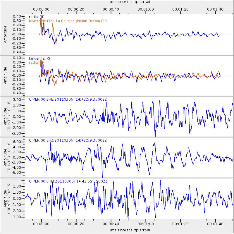
RER Riviere de l'Est, La Reunion (Indian Ocean) - Earthquake Result Viewer
*The percent match for this event was below the threshold and hence no stack was calculated.
| Earthquake location: |
South Sandwich Islands Region |
| Earthquake latitude/longitude: |
-56.4/-27.1 |
| Earthquake time(UTC): |
2011/03/06 (065) 14:32:36 GMT |
| Earthquake Depth: |
88 km |
| Earthquake Magnitude: |
6.6 MB, 6.5 MW, 6.5 MW |
| Earthquake Catalog/Contributor: |
WHDF/NEIC |
|
| Network: |
G GEOSCOPE |
| Station: |
RER Riviere de l'Est, La Reunion (Indian Ocean) |
| Lat/Lon: |
21.16 S/55.75 E |
| Elevation: |
834 m |
|
| Distance: |
68.7 deg |
| Az: |
96.301 deg |
| Baz: |
216.278 deg |
| Ray Param: |
$rayparam |
*The percent match for this event was below the threshold and hence was not used in the summary stack. |
|
| Radial Match: |
75.39256 % |
| Radial Bump: |
400 |
| Transverse Match: |
60.37561 % |
| Transverse Bump: |
400 |
| SOD ConfigId: |
354511 |
| Insert Time: |
2011-08-09 09:23:41.327 +0000 |
| GWidth: |
2.5 |
| Max Bumps: |
400 |
| Tol: |
0.001 |
|
Signal To Noise
| Channel | StoN | STA | LTA |
| G:RER:00:BHZ:20110306T14:42:59.35002Z | 2.4814093 | 1.4818925E-6 | 5.9719787E-7 |
| G:RER:00:BHN:20110306T14:42:59.35002Z | 1.32685 | 9.021282E-7 | 6.7990214E-7 |
| G:RER:00:BHE:20110306T14:42:59.35002Z | 1.2712398 | 7.3330983E-7 | 5.7684616E-7 |
| Arrivals |
| Ps | |
| PpPs | |
| PsPs/PpSs | |


