You are here: Home > Network List > G - GEOSCOPE Stations List
> Station FOMA Nahampoana reservation, Fort Dauphin, Madagascar > Earthquake Result Viewer
FOMA Nahampoana reservation, Fort Dauphin, Madagascar - Earthquake Result Viewer
| Earthquake location: |
South Sandwich Islands Region |
| Earthquake latitude/longitude: |
-56.4/-27.1 |
| Earthquake time(UTC): |
2011/03/06 (065) 14:32:36 GMT |
| Earthquake Depth: |
88 km |
| Earthquake Magnitude: |
6.6 MB, 6.5 MW, 6.5 MW |
| Earthquake Catalog/Contributor: |
WHDF/NEIC |
|
| Network: |
G GEOSCOPE |
| Station: |
FOMA Nahampoana reservation, Fort Dauphin, Madagascar |
| Lat/Lon: |
24.98 S/46.98 E |
| Elevation: |
26 m |
|
| Distance: |
60.8 deg |
| Az: |
91.698 deg |
| Baz: |
217.732 deg |
| Ray Param: |
0.061046723 |
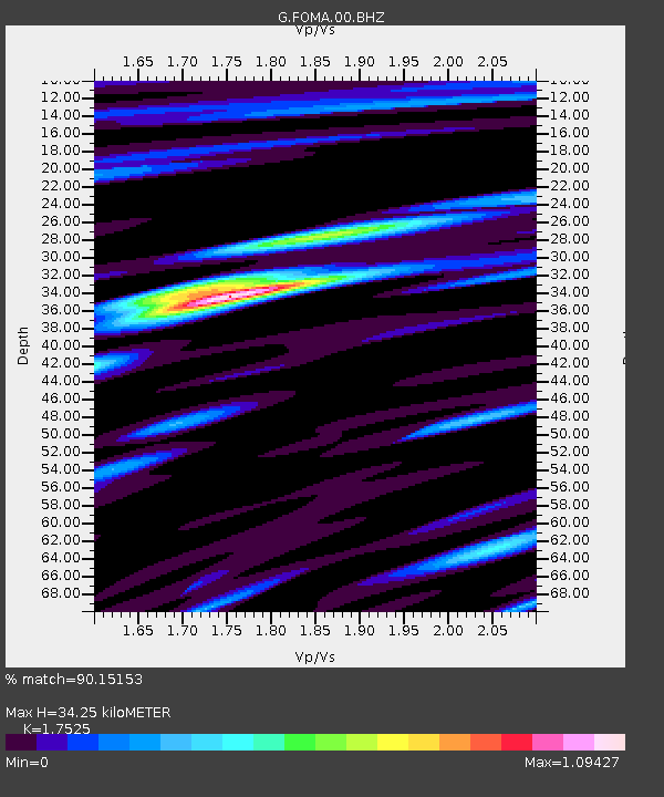
| Estimated Moho Depth: |
34.25 km |
| Estimated Crust Vp/Vs: |
1.75 |
| Assumed Crust Vp: |
6.183 km/s |
| Estimated Crust Vs: |
3.528 km/s |
| Estimated Crust Poisson's Ratio: |
0.26 |
|
| Radial Match: |
90.15153 % |
| Radial Bump: |
400 |
| Transverse Match: |
69.14474 % |
| Transverse Bump: |
400 |
| SOD ConfigId: |
354511 |
| Insert Time: |
2011-08-09 09:24:06.648 +0000 |
| GWidth: |
2.5 |
| Max Bumps: |
400 |
| Tol: |
0.001 |
|

Signal To Noise
| Channel | StoN | STA | LTA |
| G:FOMA:00:BHZ:20110306T14:42:08.299971Z | 9.278006 | 1.8610367E-6 | 2.0058586E-7 |
| G:FOMA:00:BHN:20110306T14:42:08.299971Z | 4.40165 | 7.124242E-7 | 1.618539E-7 |
| G:FOMA:00:BHE:20110306T14:42:08.299971Z | 3.1821418 | 5.548418E-7 | 1.7436112E-7 |
| Arrivals |
| Ps | 4.4 SECOND |
| PpPs | 15 SECOND |
| PsPs/PpSs | 19 SECOND |


