You are here: Home > Network List > PR - Puerto Rico Seismic Network (PRSN) & Puerto Rico Strong Motion Program (PRSMP) Stations List
> Station CRPR Cabo Rojo, Puerto Rico(T3K97) > Earthquake Result Viewer
CRPR Cabo Rojo, Puerto Rico(T3K97) - Earthquake Result Viewer
| Earthquake location: |
South Sandwich Islands Region |
| Earthquake latitude/longitude: |
-56.4/-27.1 |
| Earthquake time(UTC): |
2011/03/06 (065) 14:32:36 GMT |
| Earthquake Depth: |
88 km |
| Earthquake Magnitude: |
6.6 MB, 6.5 MW, 6.5 MW |
| Earthquake Catalog/Contributor: |
WHDF/NEIC |
|
| Network: |
PR Puerto Rico Seismic Network (PRSN) & Puerto Rico Strong Motion Program (PRSMP) |
| Station: |
CRPR Cabo Rojo, Puerto Rico(T3K97) |
| Lat/Lon: |
18.01 N/67.11 W |
| Elevation: |
65 m |
|
| Distance: |
81.4 deg |
| Az: |
321.74 deg |
| Baz: |
158.804 deg |
| Ray Param: |
0.04741569 |
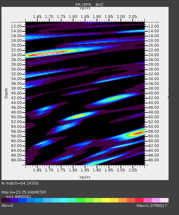
| Estimated Moho Depth: |
23.25 km |
| Estimated Crust Vp/Vs: |
1.69 |
| Assumed Crust Vp: |
5.14 km/s |
| Estimated Crust Vs: |
3.05 km/s |
| Estimated Crust Poisson's Ratio: |
0.23 |
|
| Radial Match: |
84.24305 % |
| Radial Bump: |
400 |
| Transverse Match: |
77.0195 % |
| Transverse Bump: |
400 |
| SOD ConfigId: |
354511 |
| Insert Time: |
2011-08-09 09:29:36.103 +0000 |
| GWidth: |
2.5 |
| Max Bumps: |
400 |
| Tol: |
0.001 |
|

Signal To Noise
| Channel | StoN | STA | LTA |
| PR:CRPR: :BHZ:20110306T14:44:12.275007Z | 18.464869 | 9.807839E-6 | 5.3116213E-7 |
| PR:CRPR: :BHN:20110306T14:44:12.275007Z | 6.4222646 | 2.8859952E-6 | 4.4937343E-7 |
| PR:CRPR: :BHE:20110306T14:44:12.275007Z | 4.5753803 | 1.9072827E-6 | 4.1685774E-7 |
| Arrivals |
| Ps | 3.2 SECOND |
| PpPs | 12 SECOND |
| PsPs/PpSs | 15 SECOND |


