You are here: Home > Network List > US - United States National Seismic Network Stations List
> Station EGMT Eagleton, Montana, USA > Earthquake Result Viewer
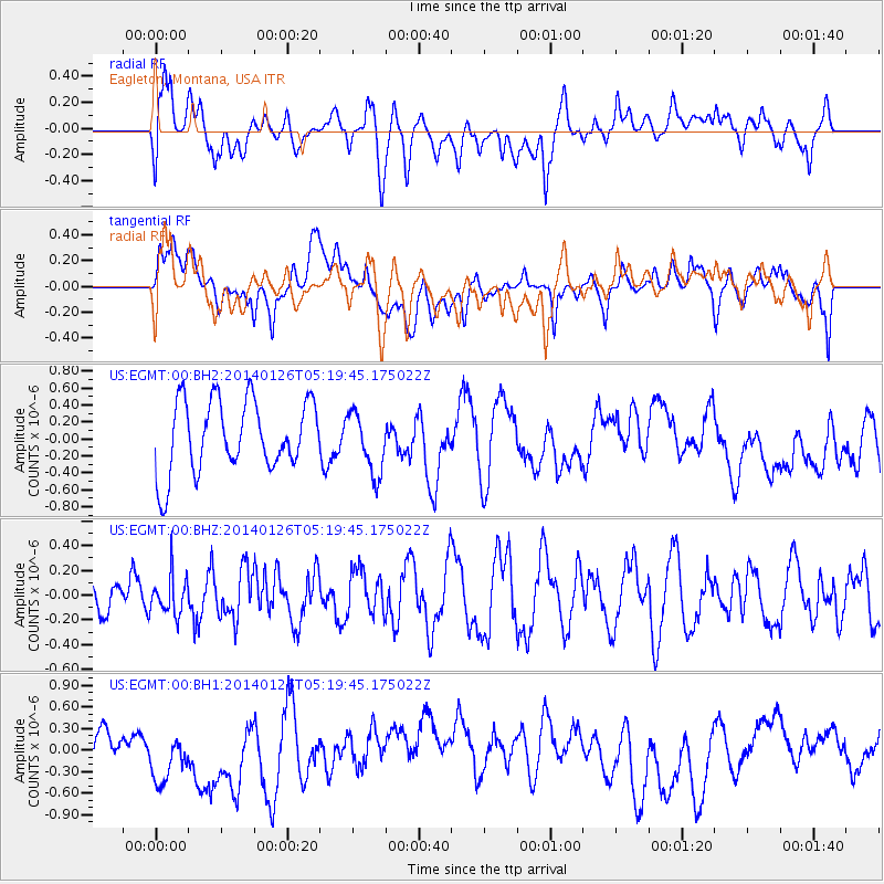
EGMT Eagleton, Montana, USA - Earthquake Result Viewer
*The percent match for this event was below the threshold and hence no stack was calculated.
| Earthquake location: |
Peru-Ecuador Border Region |
| Earthquake latitude/longitude: |
-3.8/-80.9 |
| Earthquake time(UTC): |
2014/01/26 (026) 05:10:28 GMT |
| Earthquake Depth: |
20 km |
| Earthquake Magnitude: |
5.3 MW |
| Earthquake Catalog/Contributor: |
ISC/ISC |
|
| Network: |
US United States National Seismic Network |
| Station: |
EGMT Eagleton, Montana, USA |
| Lat/Lon: |
48.02 N/109.75 W |
| Elevation: |
1055 m |
|
| Distance: |
57.5 deg |
| Az: |
337.383 deg |
| Baz: |
145.138 deg |
| Ray Param: |
$rayparam |
*The percent match for this event was below the threshold and hence was not used in the summary stack. |
|
| Radial Match: |
40.959652 % |
| Radial Bump: |
400 |
| Transverse Match: |
36.324768 % |
| Transverse Bump: |
400 |
| SOD ConfigId: |
3390531 |
| Insert Time: |
2019-04-10 02:53:41.640 +0000 |
| GWidth: |
2.5 |
| Max Bumps: |
400 |
| Tol: |
0.001 |
|
Signal To Noise
| Channel | StoN | STA | LTA |
| US:EGMT:00:BHZ:20140126T05:19:45.175022Z | 1.2056109 | 1.6204665E-7 | 1.344104E-7 |
| US:EGMT:00:BH1:20140126T05:19:45.175022Z | 2.7136738 | 4.0818716E-7 | 1.5041864E-7 |
| US:EGMT:00:BH2:20140126T05:19:45.175022Z | 0.87140733 | 3.6448168E-7 | 4.1826783E-7 |
| Arrivals |
| Ps | |
| PpPs | |
| PsPs/PpSs | |


