You are here: Home > Network List > IU - Global Seismograph Network (GSN - IRIS/USGS) Stations List
> Station TIXI Tiksi, Russia > Earthquake Result Viewer
TIXI Tiksi, Russia - Earthquake Result Viewer
| Earthquake location: |
Solomon Islands |
| Earthquake latitude/longitude: |
-10.3/160.8 |
| Earthquake time(UTC): |
2011/03/07 (066) 00:09:36 GMT |
| Earthquake Depth: |
22 km |
| Earthquake Magnitude: |
6.2 MB, 6.6 MS, 6.4 MW, 6.4 MW |
| Earthquake Catalog/Contributor: |
WHDF/NEIC |
|
| Network: |
IU Global Seismograph Network (GSN - IRIS/USGS) |
| Station: |
TIXI Tiksi, Russia |
| Lat/Lon: |
71.63 N/128.87 E |
| Elevation: |
40 m |
|
| Distance: |
84.5 deg |
| Az: |
350.312 deg |
| Baz: |
148.511 deg |
| Ray Param: |
0.04540361 |
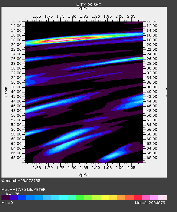
| Estimated Moho Depth: |
17.75 km |
| Estimated Crust Vp/Vs: |
1.76 |
| Assumed Crust Vp: |
6.552 km/s |
| Estimated Crust Vs: |
3.723 km/s |
| Estimated Crust Poisson's Ratio: |
0.26 |
|
| Radial Match: |
95.973785 % |
| Radial Bump: |
400 |
| Transverse Match: |
91.027115 % |
| Transverse Bump: |
400 |
| SOD ConfigId: |
354511 |
| Insert Time: |
2011-08-09 10:09:32.327 +0000 |
| GWidth: |
2.5 |
| Max Bumps: |
400 |
| Tol: |
0.001 |
|
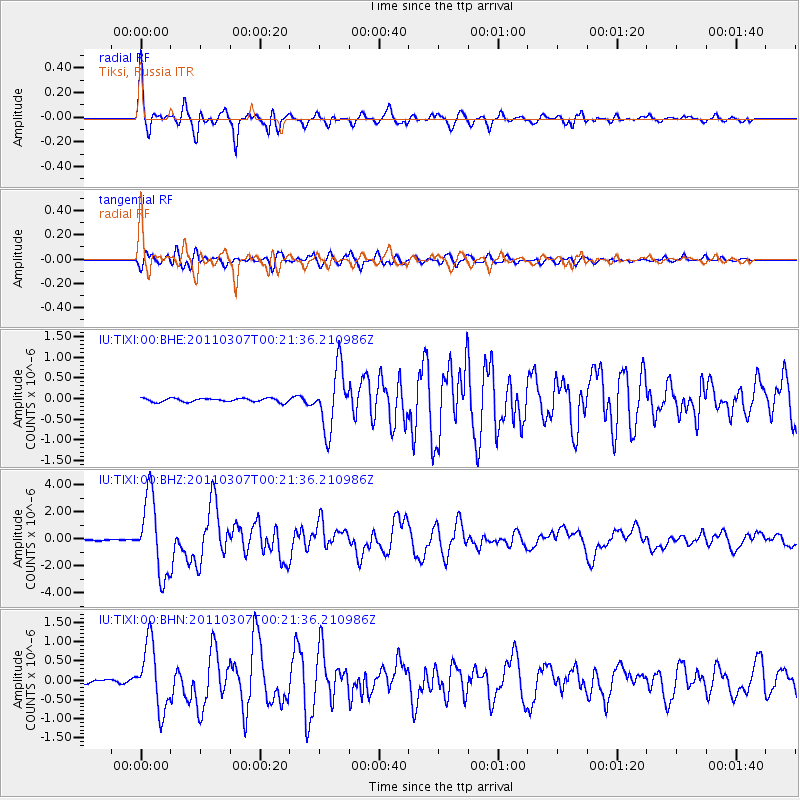
Signal To Noise
| Channel | StoN | STA | LTA |
| IU:TIXI:00:BHZ:20110307T00:21:36.210986Z | 50.658775 | 2.8349673E-6 | 5.596202E-8 |
| IU:TIXI:00:BHN:20110307T00:21:36.210986Z | 18.890583 | 8.4407725E-7 | 4.4682437E-8 |
| IU:TIXI:00:BHE:20110307T00:21:36.210986Z | 16.6412 | 7.2630417E-7 | 4.3644942E-8 |
| Arrivals |
| Ps | 2.1 SECOND |
| PpPs | 7.3 SECOND |
| PsPs/PpSs | 9.4 SECOND |


