You are here: Home > Network List > TA - USArray Transportable Network (new EarthScope stations) Stations List
> Station M02C Callahan, CA, USA > Earthquake Result Viewer
M02C Callahan, CA, USA - Earthquake Result Viewer
| Earthquake location: |
Solomon Islands |
| Earthquake latitude/longitude: |
-10.3/160.8 |
| Earthquake time(UTC): |
2011/03/07 (066) 00:09:36 GMT |
| Earthquake Depth: |
22 km |
| Earthquake Magnitude: |
6.2 MB, 6.6 MS, 6.4 MW, 6.4 MW |
| Earthquake Catalog/Contributor: |
WHDF/NEIC |
|
| Network: |
TA USArray Transportable Network (new EarthScope stations) |
| Station: |
M02C Callahan, CA, USA |
| Lat/Lon: |
41.39 N/122.85 W |
| Elevation: |
0.0 m |
|
| Distance: |
86.7 deg |
| Az: |
47.09 deg |
| Baz: |
253.299 deg |
| Ray Param: |
0.043806177 |
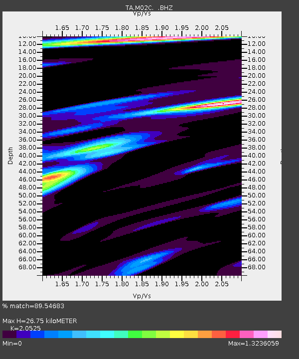
| Estimated Moho Depth: |
26.75 km |
| Estimated Crust Vp/Vs: |
2.05 |
| Assumed Crust Vp: |
6.566 km/s |
| Estimated Crust Vs: |
3.199 km/s |
| Estimated Crust Poisson's Ratio: |
0.34 |
|
| Radial Match: |
89.54683 % |
| Radial Bump: |
400 |
| Transverse Match: |
75.67671 % |
| Transverse Bump: |
400 |
| SOD ConfigId: |
354511 |
| Insert Time: |
2011-08-09 10:21:23.941 +0000 |
| GWidth: |
2.5 |
| Max Bumps: |
400 |
| Tol: |
0.001 |
|

Signal To Noise
| Channel | StoN | STA | LTA |
| TA:M02C: :BHZ:20110307T00:21:47.249988Z | 6.3385797 | 1.9742433E-6 | 3.1146462E-7 |
| TA:M02C: :BHN:20110307T00:21:47.249988Z | 1.0619617 | 1.7260979E-7 | 1.6253863E-7 |
| TA:M02C: :BHE:20110307T00:21:47.249988Z | 2.5985086 | 5.567743E-7 | 2.1426685E-7 |
| Arrivals |
| Ps | 4.4 SECOND |
| PpPs | 12 SECOND |
| PsPs/PpSs | 17 SECOND |


