You are here: Home > Network List > TA - USArray Transportable Network (new EarthScope stations) Stations List
> Station I04A Tendick Farm, Oakridge, OR, USA > Earthquake Result Viewer
I04A Tendick Farm, Oakridge, OR, USA - Earthquake Result Viewer
| Earthquake location: |
Solomon Islands |
| Earthquake latitude/longitude: |
-10.3/160.8 |
| Earthquake time(UTC): |
2011/03/07 (066) 00:09:36 GMT |
| Earthquake Depth: |
22 km |
| Earthquake Magnitude: |
6.2 MB, 6.6 MS, 6.4 MW, 6.4 MW |
| Earthquake Catalog/Contributor: |
WHDF/NEIC |
|
| Network: |
TA USArray Transportable Network (new EarthScope stations) |
| Station: |
I04A Tendick Farm, Oakridge, OR, USA |
| Lat/Lon: |
43.79 N/122.41 W |
| Elevation: |
731 m |
|
| Distance: |
87.7 deg |
| Az: |
44.88 deg |
| Baz: |
253.492 deg |
| Ray Param: |
0.043080326 |
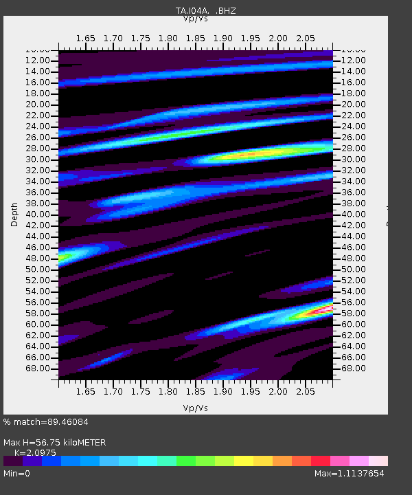
| Estimated Moho Depth: |
56.75 km |
| Estimated Crust Vp/Vs: |
2.10 |
| Assumed Crust Vp: |
6.522 km/s |
| Estimated Crust Vs: |
3.109 km/s |
| Estimated Crust Poisson's Ratio: |
0.35 |
|
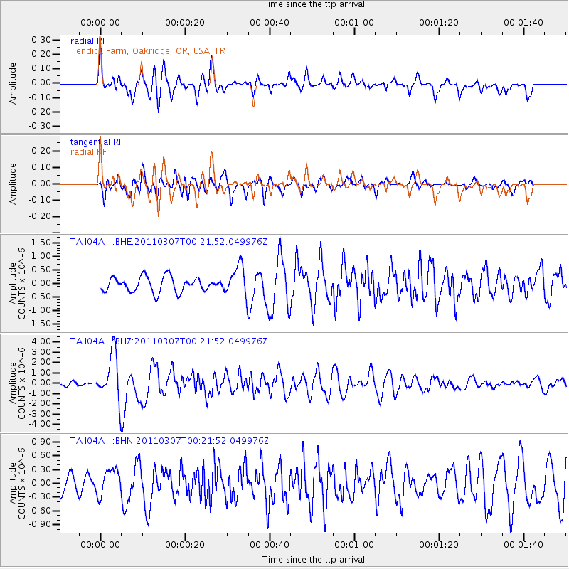
| Radial Match: |
89.46084 % |
| Radial Bump: |
400 |
| Transverse Match: |
72.64474 % |
| Transverse Bump: |
400 |
| SOD ConfigId: |
354511 |
| Insert Time: |
2011-08-09 10:21:54.520 +0000 |
| GWidth: |
2.5 |
| Max Bumps: |
400 |
| Tol: |
0.001 |
|
Signal To Noise
| Channel | StoN | STA | LTA |
| TA:I04A: :BHZ:20110307T00:21:52.049976Z | 7.9582014 | 2.3078453E-6 | 2.8999585E-7 |
| TA:I04A: :BHN:20110307T00:21:52.049976Z | 1.4132143 | 2.825793E-7 | 1.9995502E-7 |
| TA:I04A: :BHE:20110307T00:21:52.049976Z | 2.0450044 | 5.778782E-7 | 2.8258043E-7 |
| Arrivals |
| Ps | 9.7 SECOND |
| PpPs | 26 SECOND |
| PsPs/PpSs | 36 SECOND |


