You are here: Home > Network List > AZ - ANZA Regional Network Stations List
> Station KNW AZ.KNW > Earthquake Result Viewer
KNW AZ.KNW - Earthquake Result Viewer
| Earthquake location: |
North Of Honduras |
| Earthquake latitude/longitude: |
16.7/-86.2 |
| Earthquake time(UTC): |
2009/05/28 (148) 08:24:45 GMT |
| Earthquake Depth: |
10 km |
| Earthquake Magnitude: |
6.7 MB, 7.2 MS, 7.3 MW, 7.3 MW |
| Earthquake Catalog/Contributor: |
WHDF/NEIC |
|
| Network: |
AZ ANZA Regional Network |
| Station: |
KNW AZ.KNW |
| Lat/Lon: |
33.71 N/116.71 W |
| Elevation: |
1507 m |
|
| Distance: |
32.2 deg |
| Az: |
307.465 deg |
| Baz: |
114.149 deg |
| Ray Param: |
0.0787591 |
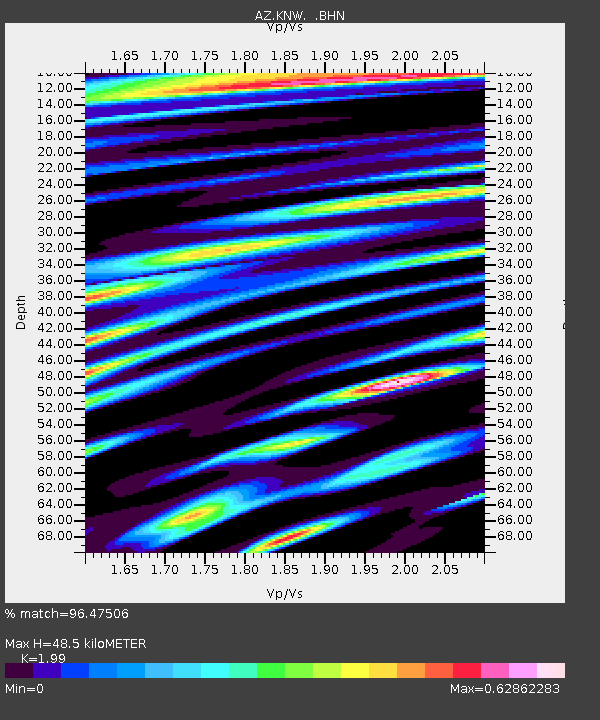
| Estimated Moho Depth: |
48.5 km |
| Estimated Crust Vp/Vs: |
1.99 |
| Assumed Crust Vp: |
6.264 km/s |
| Estimated Crust Vs: |
3.148 km/s |
| Estimated Crust Poisson's Ratio: |
0.33 |
|
| Radial Match: |
96.47506 % |
| Radial Bump: |
353 |
| Transverse Match: |
90.01368 % |
| Transverse Bump: |
400 |
| SOD ConfigId: |
2648 |
| Insert Time: |
2010-02-26 19:35:02.674 +0000 |
| GWidth: |
2.5 |
| Max Bumps: |
400 |
| Tol: |
0.001 |
|

Signal To Noise
| Channel | StoN | STA | LTA |
| AZ:KNW: :BHN:20090528T08:30:42.345015Z | 25.866234 | 4.4404096E-6 | 1.716682E-7 |
| AZ:KNW: :BHE:20090528T08:30:42.345015Z | 14.405634 | 1.0969751E-6 | 7.6149036E-8 |
| AZ:KNW: :BHZ:20090528T08:30:42.345015Z | 25.408728 | 2.890554E-6 | 1.1376225E-7 |
| Arrivals |
| Ps | 8.2 SECOND |
| PpPs | 22 SECOND |
| PsPs/PpSs | 30 SECOND |


