You are here: Home > Network List > TA - USArray Transportable Network (new EarthScope stations) Stations List
> Station G03D McMinnville, OR, USA > Earthquake Result Viewer
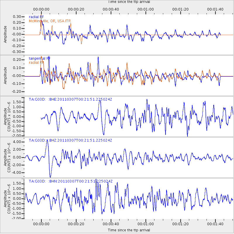
G03D McMinnville, OR, USA - Earthquake Result Viewer
*The percent match for this event was below the threshold and hence no stack was calculated.
| Earthquake location: |
Solomon Islands |
| Earthquake latitude/longitude: |
-10.3/160.8 |
| Earthquake time(UTC): |
2011/03/07 (066) 00:09:36 GMT |
| Earthquake Depth: |
22 km |
| Earthquake Magnitude: |
6.2 MB, 6.6 MS, 6.4 MW, 6.4 MW |
| Earthquake Catalog/Contributor: |
WHDF/NEIC |
|
| Network: |
TA USArray Transportable Network (new EarthScope stations) |
| Station: |
G03D McMinnville, OR, USA |
| Lat/Lon: |
45.21 N/123.26 W |
| Elevation: |
222 m |
|
| Distance: |
87.6 deg |
| Az: |
43.346 deg |
| Baz: |
252.833 deg |
| Ray Param: |
$rayparam |
*The percent match for this event was below the threshold and hence was not used in the summary stack. |
|
| Radial Match: |
75.03272 % |
| Radial Bump: |
400 |
| Transverse Match: |
77.93927 % |
| Transverse Bump: |
400 |
| SOD ConfigId: |
354511 |
| Insert Time: |
2011-08-09 10:26:00.312 +0000 |
| GWidth: |
2.5 |
| Max Bumps: |
400 |
| Tol: |
0.001 |
|
Signal To Noise
| Channel | StoN | STA | LTA |
| TA:G03D: :BHZ:20110307T00:21:51.225024Z | 5.7100964 | 2.2156319E-6 | 3.8802006E-7 |
| TA:G03D: :BHN:20110307T00:21:51.225024Z | 0.97903585 | 2.9368908E-7 | 2.9997787E-7 |
| TA:G03D: :BHE:20110307T00:21:51.225024Z | 1.7408847 | 8.158E-7 | 4.686123E-7 |
| Arrivals |
| Ps | |
| PpPs | |
| PsPs/PpSs | |


