You are here: Home > Network List > TA - USArray Transportable Network (new EarthScope stations) Stations List
> Station L04D Klamath Falls, OR, USA > Earthquake Result Viewer
L04D Klamath Falls, OR, USA - Earthquake Result Viewer
*The percent match for this event was below the threshold and hence no stack was calculated.
| Earthquake location: |
Solomon Islands |
| Earthquake latitude/longitude: |
-10.3/160.8 |
| Earthquake time(UTC): |
2011/03/07 (066) 00:09:36 GMT |
| Earthquake Depth: |
22 km |
| Earthquake Magnitude: |
6.2 MB, 6.6 MS, 6.4 MW, 6.4 MW |
| Earthquake Catalog/Contributor: |
WHDF/NEIC |
|
| Network: |
TA USArray Transportable Network (new EarthScope stations) |
| Station: |
L04D Klamath Falls, OR, USA |
| Lat/Lon: |
42.22 N/122.30 W |
| Elevation: |
1437 m |
|
| Distance: |
87.4 deg |
| Az: |
46.415 deg |
| Baz: |
253.629 deg |
| Ray Param: |
$rayparam |
*The percent match for this event was below the threshold and hence was not used in the summary stack. |
|
| Radial Match: |
73.84478 % |
| Radial Bump: |
400 |
| Transverse Match: |
66.454094 % |
| Transverse Bump: |
400 |
| SOD ConfigId: |
354511 |
| Insert Time: |
2011-08-09 10:27:04.009 +0000 |
| GWidth: |
2.5 |
| Max Bumps: |
400 |
| Tol: |
0.001 |
|
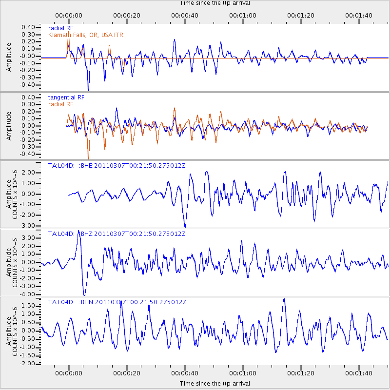
Signal To Noise
| Channel | StoN | STA | LTA |
| TA:L04D: :BHZ:20110307T00:21:50.275012Z | 15.894628 | 1.8475915E-6 | 1.1624E-7 |
| TA:L04D: :BHN:20110307T00:21:50.275012Z | 1.1327683 | 4.7379936E-7 | 4.1826678E-7 |
| TA:L04D: :BHE:20110307T00:21:50.275012Z | 1.5323228 | 5.1331614E-7 | 3.3499217E-7 |
| Arrivals |
| Ps | |
| PpPs | |
| PsPs/PpSs | |


