You are here: Home > Network List > TA - USArray Transportable Network (new EarthScope stations) Stations List
> Station C06D Leavenworth, WQ, USA > Earthquake Result Viewer
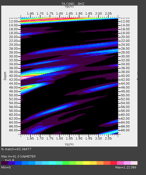
C06D Leavenworth, WQ, USA - Earthquake Result Viewer
| Earthquake location: |
Solomon Islands |
| Earthquake latitude/longitude: |
-10.3/160.8 |
| Earthquake time(UTC): |
2011/03/07 (066) 00:09:36 GMT |
| Earthquake Depth: |
22 km |
| Earthquake Magnitude: |
6.2 MB, 6.6 MS, 6.4 MW, 6.4 MW |
| Earthquake Catalog/Contributor: |
WHDF/NEIC |
|
| Network: |
TA USArray Transportable Network (new EarthScope stations) |
| Station: |
C06D Leavenworth, WQ, USA |
| Lat/Lon: |
47.92 N/120.89 W |
| Elevation: |
544 m |
|
| Distance: |
89.9 deg |
| Az: |
41.203 deg |
| Baz: |
254.502 deg |
| Ray Param: |
0.041709516 |
| Estimated Moho Depth: |
41.0 km |
| Estimated Crust Vp/Vs: |
1.60 |
| Assumed Crust Vp: |
6.597 km/s |
| Estimated Crust Vs: |
4.123 km/s |
| Estimated Crust Poisson's Ratio: |
0.18 |
|
| Radial Match: |
83.36477 % |
| Radial Bump: |
400 |
| Transverse Match: |
45.948444 % |
| Transverse Bump: |
400 |
| SOD ConfigId: |
354511 |
| Insert Time: |
2011-08-09 10:31:39.283 +0000 |
| GWidth: |
2.5 |
| Max Bumps: |
400 |
| Tol: |
0.001 |
|

Signal To Noise
| Channel | StoN | STA | LTA |
| TA:C06D: :BHZ:20110307T00:22:02.200Z | 18.932978 | 1.2361617E-6 | 6.529146E-8 |
| TA:C06D: :BHN:20110307T00:22:02.200Z | 0.81361103 | 1.8308538E-7 | 2.2502813E-7 |
| TA:C06D: :BHE:20110307T00:22:02.200Z | 4.4641743 | 3.7097865E-7 | 8.31013E-8 |
| Arrivals |
| Ps | 3.8 SECOND |
| PpPs | 16 SECOND |
| PsPs/PpSs | 20 SECOND |


