You are here: Home > Network List > UW - Pacific Northwest Regional Seismic Network Stations List
> Station LCCR Mulino, OR, USA > Earthquake Result Viewer
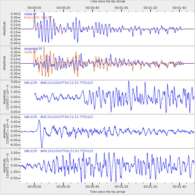
LCCR Mulino, OR, USA - Earthquake Result Viewer
*The percent match for this event was below the threshold and hence no stack was calculated.
| Earthquake location: |
Solomon Islands |
| Earthquake latitude/longitude: |
-10.3/160.8 |
| Earthquake time(UTC): |
2011/03/07 (066) 00:09:36 GMT |
| Earthquake Depth: |
22 km |
| Earthquake Magnitude: |
6.2 MB, 6.6 MS, 6.4 MW, 6.4 MW |
| Earthquake Catalog/Contributor: |
WHDF/NEIC |
|
| Network: |
UW Pacific Northwest Regional Seismic Network |
| Station: |
LCCR Mulino, OR, USA |
| Lat/Lon: |
45.21 N/122.48 W |
| Elevation: |
273 m |
|
| Distance: |
88.1 deg |
| Az: |
43.513 deg |
| Baz: |
253.395 deg |
| Ray Param: |
$rayparam |
*The percent match for this event was below the threshold and hence was not used in the summary stack. |
|
| Radial Match: |
77.8219 % |
| Radial Bump: |
400 |
| Transverse Match: |
77.038994 % |
| Transverse Bump: |
400 |
| SOD ConfigId: |
354511 |
| Insert Time: |
2011-08-09 10:47:39.977 +0000 |
| GWidth: |
2.5 |
| Max Bumps: |
400 |
| Tol: |
0.001 |
|
Signal To Noise
| Channel | StoN | STA | LTA |
| UW:LCCR: :BHZ:20110307T00:21:53.775012Z | 10.440959 | 2.5004397E-6 | 2.394837E-7 |
| UW:LCCR: :BHN:20110307T00:21:53.775012Z | 0.9470245 | 2.7988742E-7 | 2.95544E-7 |
| UW:LCCR: :BHE:20110307T00:21:53.775012Z | 1.6253496 | 6.478861E-7 | 3.9861337E-7 |
| Arrivals |
| Ps | |
| PpPs | |
| PsPs/PpSs | |


