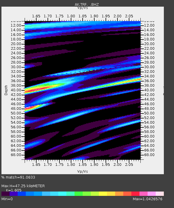
TRF Thorofare Mountian - Earthquake Result Viewer

Earthquake location: Near East Coast Of Honshu, Japan
Earthquake latitude/longitude: 38.4/142.8
Earthquake time(UTC): 2011/03/09 (068) 02:45:20 GMT
Earthquake Depth: 32 km
Earthquake Magnitude: 6.4 MB, 7.3 MS, 7.5 MW, 7.3 MW
Earthquake Catalog/Contributor: WHDF/NEIC
Network: AK Alaska Regional Network
Station: TRF Thorofare Mountian
Lat/Lon: 63.45 N/150.29 W
Elevation: 1717 m
Distance: 46.2 deg
Az: 34.903 deg
Baz: 270.206 deg
Ray Param: 0.07070793
Estimated Moho Depth: 47.25 km
Estimated Crust Vp/Vs: 1.61
Assumed Crust Vp: 6.438 km/s
Estimated Crust Vs: 4.011 km/s
Estimated Crust Poisson's Ratio: 0.18
Radial Match: 91.0633 %
Radial Bump: 400
Transverse Match: 79.06131 %
Transverse Bump: 400
SOD ConfigId: 354511
Insert Time: 2011-08-09 10:55:00.516 +0000
GWidth: 2.5
Max Bumps: 400
Tol: 0.001

Signal To Noise

ChannelStoNSTALTA
AK:TRF: :BHZ:20110309T02:53:11.900007Z2.09952935.794385E-72.7598495E-7
AK:TRF: :BHN:20110309T02:53:11.900007Z1.22791793.960581E-73.2254445E-7
AK:TRF: :BHE:20110309T02:53:11.900007Z1.64665735.466919E-73.3200104E-7
Arrivals
Ps4.8 SECOND
PpPs18 SECOND
PsPs/PpSs23 SECOND