You are here: Home > Network List > AZ - ANZA Regional Network Stations List
> Station KNW AZ.KNW > Earthquake Result Viewer
KNW AZ.KNW - Earthquake Result Viewer
| Earthquake location: |
East Of Kuril Islands |
| Earthquake latitude/longitude: |
46.7/155.5 |
| Earthquake time(UTC): |
2006/11/28 (332) 08:01:51 GMT |
| Earthquake Depth: |
10 km |
| Earthquake Magnitude: |
5.6 MB, 5.2 MW, 5.2 MW |
| Earthquake Catalog/Contributor: |
WHDF/NEIC |
|
| Network: |
AZ ANZA Regional Network |
| Station: |
KNW AZ.KNW |
| Lat/Lon: |
33.71 N/116.71 W |
| Elevation: |
1507 m |
|
| Distance: |
65.0 deg |
| Az: |
66.819 deg |
| Baz: |
310.603 deg |
| Ray Param: |
0.05858305 |
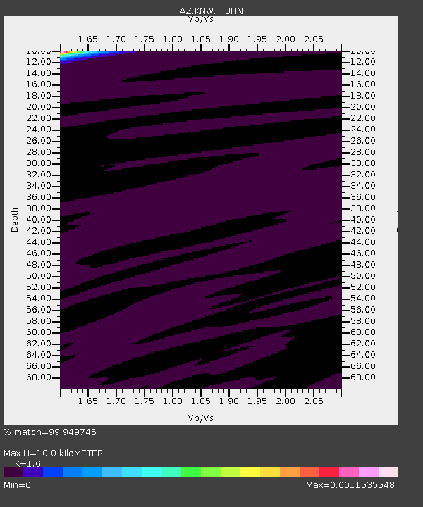
| Estimated Moho Depth: |
10.0 km |
| Estimated Crust Vp/Vs: |
1.60 |
| Assumed Crust Vp: |
6.264 km/s |
| Estimated Crust Vs: |
3.915 km/s |
| Estimated Crust Poisson's Ratio: |
0.18 |
|
| Radial Match: |
99.949745 % |
| Radial Bump: |
2 |
| Transverse Match: |
99.82066 % |
| Transverse Bump: |
24 |
| SOD ConfigId: |
2564 |
| Insert Time: |
2010-02-26 19:35:18.254 +0000 |
| GWidth: |
2.5 |
| Max Bumps: |
400 |
| Tol: |
0.001 |
|
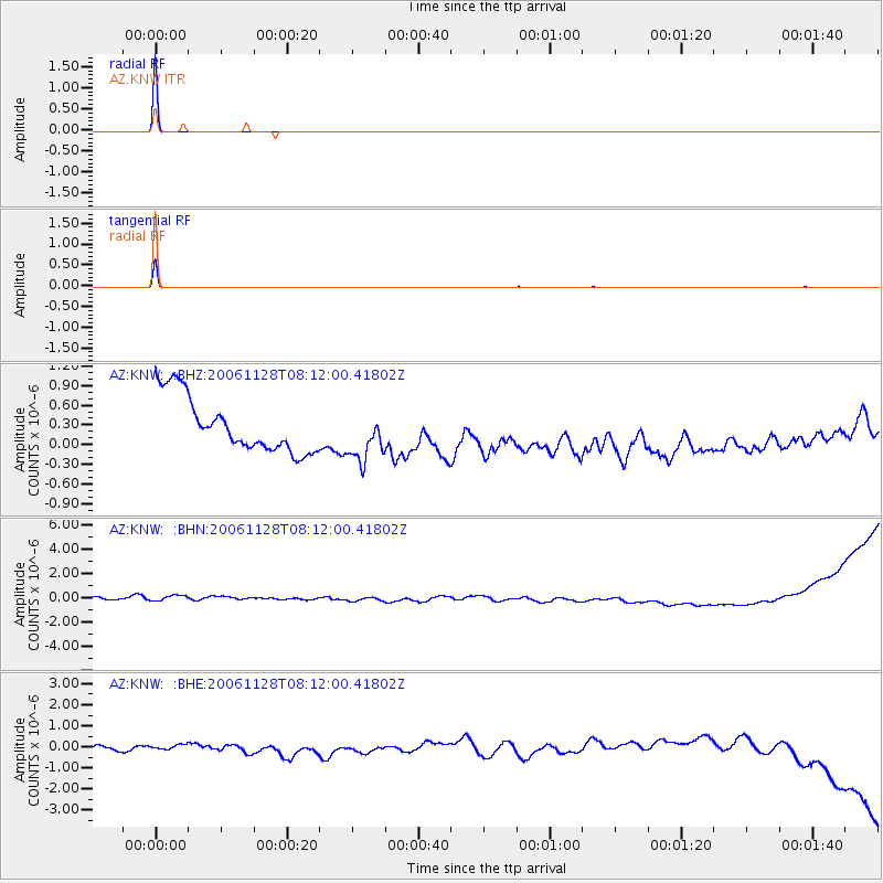
Signal To Noise
| Channel | StoN | STA | LTA |
| AZ:KNW: :BHN:20061128T08:12:00.41802Z | 1.0974473 | 6.0883866E-7 | 5.5477716E-7 |
| AZ:KNW: :BHE:20061128T08:12:00.41802Z | 0.414832 | 1.2741191E-7 | 3.07141E-7 |
| AZ:KNW: :BHZ:20061128T08:12:00.41802Z | 0.94159424 | 3.9310075E-7 | 4.1748422E-7 |
| Arrivals |
| Ps | 1.0 SECOND |
| PpPs | 4.0 SECOND |
| PsPs/PpSs | 5.0 SECOND |


