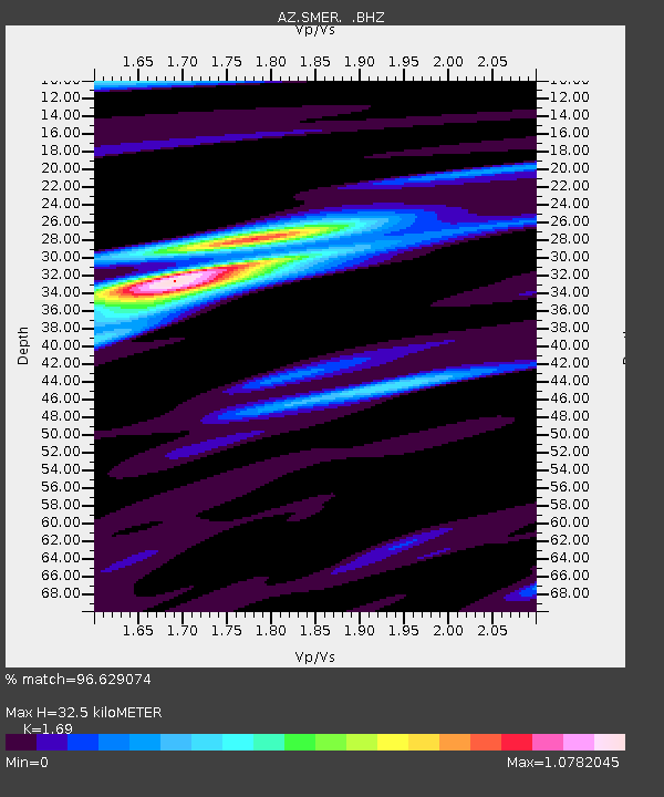
SMER AZ.SMER - Earthquake Result Viewer
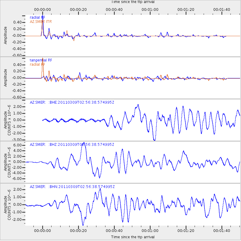
Earthquake location: Near East Coast Of Honshu, Japan
Earthquake latitude/longitude: 38.4/142.8
Earthquake time(UTC): 2011/03/09 (068) 02:45:20 GMT
Earthquake Depth: 32 km
Earthquake Magnitude: 6.4 MB, 7.3 MS, 7.5 MW, 7.3 MW
Earthquake Catalog/Contributor: WHDF/NEIC
Network: AZ ANZA Regional Network
Station: SMER AZ.SMER
Lat/Lon: 33.46 N/117.17 W
Elevation: 355 m
Distance: 76.9 deg
Az: 57.689 deg
Baz: 307.443 deg
Ray Param: 0.05060818
Estimated Moho Depth: 32.5 km
Estimated Crust Vp/Vs: 1.69
Assumed Crust Vp: 6.264 km/s
Estimated Crust Vs: 3.706 km/s
Estimated Crust Poisson's Ratio: 0.23
Radial Match: 96.629074 %
Radial Bump: 215
Transverse Match: 82.71667 %
Transverse Bump: 400
SOD ConfigId: 354511
Insert Time: 2011-08-09 11:09:06.932 +0000
GWidth: 2.5
Max Bumps: 400
Tol: 0.001

Signal To Noise

ChannelStoNSTALTA
AZ:SMER: :BHZ:20110309T02:56:38.574995Z1.82248562.8433706E-71.5601609E-7
AZ:SMER: :BHN:20110309T02:56:38.574995Z1.02771091.274636E-71.2402671E-7
AZ:SMER: :BHE:20110309T02:56:38.574995Z0.74878291.04504544E-71.3956588E-7
Arrivals
Ps3.7 SECOND
PpPs14 SECOND
PsPs/PpSs17 SECOND