You are here: Home > Network List > AZ - ANZA Regional Network Stations List
> Station KNW AZ.KNW > Earthquake Result Viewer
KNW AZ.KNW - Earthquake Result Viewer
| Earthquake location: |
Kuril Islands |
| Earthquake latitude/longitude: |
46.6/153.3 |
| Earthquake time(UTC): |
2006/11/15 (319) 11:14:13 GMT |
| Earthquake Depth: |
10 km |
| Earthquake Magnitude: |
6.5 MB, 7.8 MS, 8.3 MW, 7.9 MW |
| Earthquake Catalog/Contributor: |
WHDF/NEIC |
|
| Network: |
AZ ANZA Regional Network |
| Station: |
KNW AZ.KNW |
| Lat/Lon: |
33.71 N/116.71 W |
| Elevation: |
1507 m |
|
| Distance: |
66.4 deg |
| Az: |
65.422 deg |
| Baz: |
311.202 deg |
| Ray Param: |
0.057621278 |
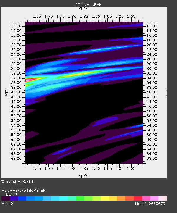
| Estimated Moho Depth: |
34.75 km |
| Estimated Crust Vp/Vs: |
1.60 |
| Assumed Crust Vp: |
6.264 km/s |
| Estimated Crust Vs: |
3.915 km/s |
| Estimated Crust Poisson's Ratio: |
0.18 |
|
| Radial Match: |
98.8149 % |
| Radial Bump: |
254 |
| Transverse Match: |
93.22161 % |
| Transverse Bump: |
390 |
| SOD ConfigId: |
2564 |
| Insert Time: |
2010-02-26 19:35:22.758 +0000 |
| GWidth: |
2.5 |
| Max Bumps: |
400 |
| Tol: |
0.001 |
|

Signal To Noise
| Channel | StoN | STA | LTA |
| AZ:KNW: :BHN:20061115T11:24:31.668022Z | 1.9206909 | 4.0515482E-7 | 2.1094222E-7 |
| AZ:KNW: :BHE:20061115T11:24:31.668022Z | 1.0161312 | 2.4820653E-7 | 2.4426626E-7 |
| AZ:KNW: :BHZ:20061115T11:24:31.668022Z | 4.818055 | 1.1141409E-6 | 2.3124285E-7 |
| Arrivals |
| Ps | 3.5 SECOND |
| PpPs | 14 SECOND |
| PsPs/PpSs | 17 SECOND |


