You are here: Home > Network List > AZ - ANZA Regional Network Stations List
> Station KNW AZ.KNW > Earthquake Result Viewer
KNW AZ.KNW - Earthquake Result Viewer
| Earthquake location: |
Santiago Del Estero Prov., Arg. |
| Earthquake latitude/longitude: |
-26.0/-63.2 |
| Earthquake time(UTC): |
2006/11/13 (317) 01:26:34 GMT |
| Earthquake Depth: |
552 km |
| Earthquake Magnitude: |
6.3 MB, 6.8 MW, 6.8 MW |
| Earthquake Catalog/Contributor: |
WHDF/NEIC |
|
| Network: |
AZ ANZA Regional Network |
| Station: |
KNW AZ.KNW |
| Lat/Lon: |
33.71 N/116.71 W |
| Elevation: |
1507 m |
|
| Distance: |
78.2 deg |
| Az: |
316.805 deg |
| Baz: |
132.373 deg |
| Ray Param: |
0.048123688 |
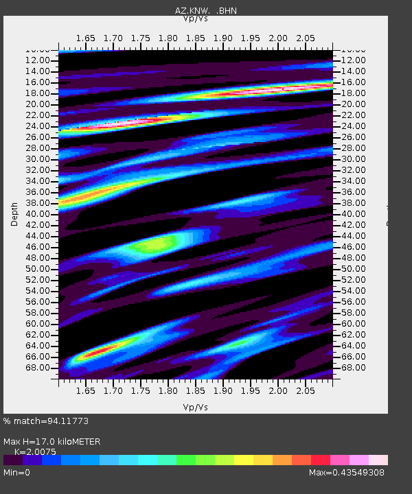
| Estimated Moho Depth: |
17.0 km |
| Estimated Crust Vp/Vs: |
2.01 |
| Assumed Crust Vp: |
6.264 km/s |
| Estimated Crust Vs: |
3.12 km/s |
| Estimated Crust Poisson's Ratio: |
0.33 |
|
| Radial Match: |
94.11773 % |
| Radial Bump: |
400 |
| Transverse Match: |
84.550865 % |
| Transverse Bump: |
400 |
| SOD ConfigId: |
2564 |
| Insert Time: |
2010-02-26 19:35:24.378 +0000 |
| GWidth: |
2.5 |
| Max Bumps: |
400 |
| Tol: |
0.001 |
|
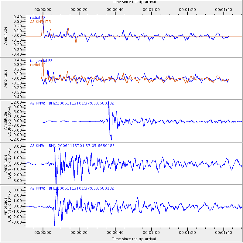
Signal To Noise
| Channel | StoN | STA | LTA |
| AZ:KNW: :BHN:20061113T01:37:05.668018Z | 0.65833837 | 1.6099592E-7 | 2.4454891E-7 |
| AZ:KNW: :BHE:20061113T01:37:05.668018Z | 0.5012259 | 8.676125E-8 | 1.730981E-7 |
| AZ:KNW: :BHZ:20061113T01:37:05.668018Z | 1.2146516 | 3.4717252E-7 | 2.8582065E-7 |
| Arrivals |
| Ps | 2.8 SECOND |
| PpPs | 8.0 SECOND |
| PsPs/PpSs | 11 SECOND |


