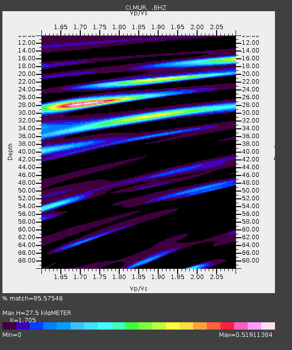
MUR Murrieta - Earthquake Result Viewer
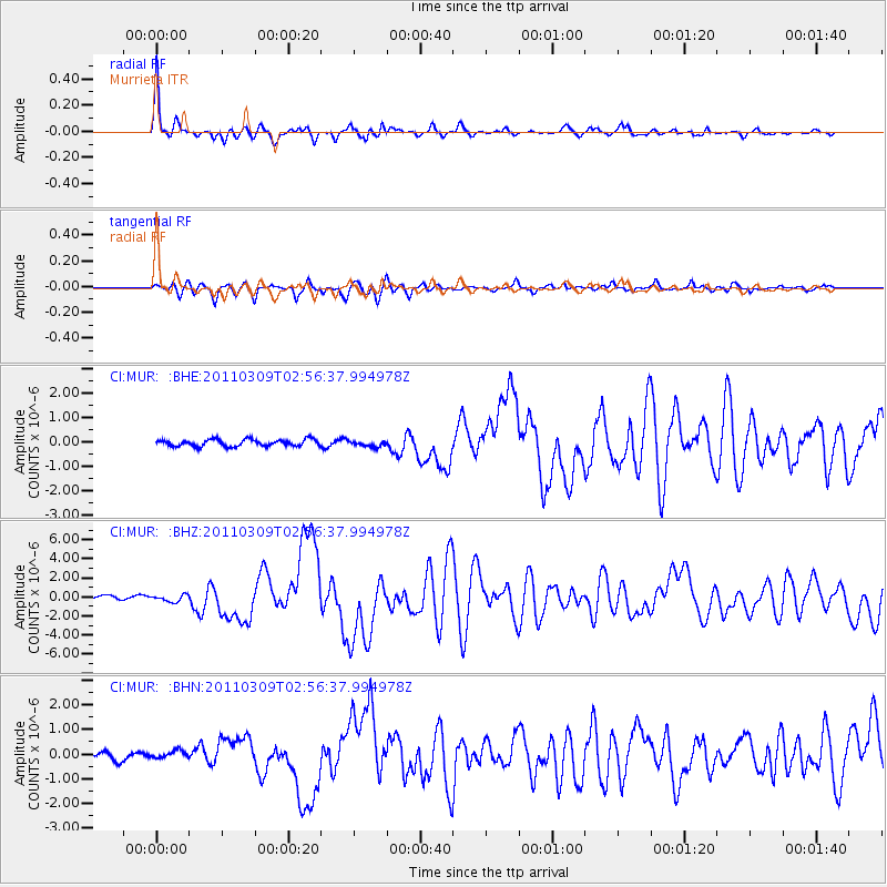
Earthquake location: Near East Coast Of Honshu, Japan
Earthquake latitude/longitude: 38.4/142.8
Earthquake time(UTC): 2011/03/09 (068) 02:45:20 GMT
Earthquake Depth: 32 km
Earthquake Magnitude: 6.4 MB, 7.3 MS, 7.5 MW, 7.3 MW
Earthquake Catalog/Contributor: WHDF/NEIC
Network: CI Caltech Regional Seismic Network
Station: MUR Murrieta
Lat/Lon: 33.60 N/117.20 W
Elevation: 562 m
Distance: 76.8 deg
Az: 57.586 deg
Baz: 307.407 deg
Ray Param: 0.05067678
Estimated Moho Depth: 27.5 km
Estimated Crust Vp/Vs: 1.71
Assumed Crust Vp: 6.264 km/s
Estimated Crust Vs: 3.674 km/s
Estimated Crust Poisson's Ratio: 0.24
Radial Match: 95.57546 %
Radial Bump: 337
Transverse Match: 84.31209 %
Transverse Bump: 400
SOD ConfigId: 354511
Insert Time: 2011-08-09 11:24:38.088 +0000
GWidth: 2.5
Max Bumps: 400
Tol: 0.001

Signal To Noise

ChannelStoNSTALTA
CI:MUR: :BHZ:20110309T02:56:37.994978Z1.92599483.543691E-71.8399277E-7
CI:MUR: :BHN:20110309T02:56:37.994978Z0.85812561.624707E-71.8933207E-7
CI:MUR: :BHE:20110309T02:56:37.994978Z0.868919851.2107762E-71.3934269E-7
Arrivals
Ps3.2 SECOND
PpPs12 SECOND
PsPs/PpSs15 SECOND