You are here: Home > Network List > TA - USArray Transportable Network (new EarthScope stations) Stations List
> Station Z41A Richland Creek Farm, El Dorado, AR, USA > Earthquake Result Viewer
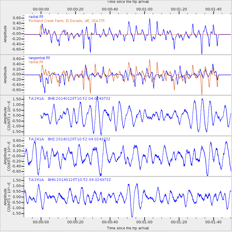
Z41A Richland Creek Farm, El Dorado, AR, USA - Earthquake Result Viewer
*The percent match for this event was below the threshold and hence no stack was calculated.
| Earthquake location: |
Tonga Islands |
| Earthquake latitude/longitude: |
-15.4/-173.5 |
| Earthquake time(UTC): |
2014/01/26 (026) 10:39:36 GMT |
| Earthquake Depth: |
42 km |
| Earthquake Magnitude: |
5.5 MW |
| Earthquake Catalog/Contributor: |
ISC/ISC |
|
| Network: |
TA USArray Transportable Network (new EarthScope stations) |
| Station: |
Z41A Richland Creek Farm, El Dorado, AR, USA |
| Lat/Lon: |
33.26 N/92.80 W |
| Elevation: |
62 m |
|
| Distance: |
90.7 deg |
| Az: |
55.778 deg |
| Baz: |
252.143 deg |
| Ray Param: |
$rayparam |
*The percent match for this event was below the threshold and hence was not used in the summary stack. |
|
| Radial Match: |
53.063576 % |
| Radial Bump: |
340 |
| Transverse Match: |
50.2678 % |
| Transverse Bump: |
337 |
| SOD ConfigId: |
3390531 |
| Insert Time: |
2019-04-10 03:02:41.645 +0000 |
| GWidth: |
2.5 |
| Max Bumps: |
400 |
| Tol: |
0.001 |
|
Signal To Noise
| Channel | StoN | STA | LTA |
| TA:Z41A: :BHZ:20140126T10:52:04.024973Z | 1.1919451 | 2.5702684E-7 | 2.1563649E-7 |
| TA:Z41A: :BHN:20140126T10:52:04.024973Z | 1.1901878 | 5.353964E-7 | 4.4984193E-7 |
| TA:Z41A: :BHE:20140126T10:52:04.024973Z | 2.1798117 | 1.1410074E-6 | 5.2344313E-7 |
| Arrivals |
| Ps | |
| PpPs | |
| PsPs/PpSs | |


