You are here: Home > Network List > AZ - ANZA Regional Network Stations List
> Station KNW AZ.KNW > Earthquake Result Viewer
KNW AZ.KNW - Earthquake Result Viewer
| Earthquake location: |
Kuril Islands |
| Earthquake latitude/longitude: |
46.5/153.2 |
| Earthquake time(UTC): |
2006/10/01 (274) 09:06:02 GMT |
| Earthquake Depth: |
19 km |
| Earthquake Magnitude: |
6.1 MB, 6.4 MS, 6.6 MW, 6.5 MW |
| Earthquake Catalog/Contributor: |
WHDF/NEIC |
|
| Network: |
AZ ANZA Regional Network |
| Station: |
KNW AZ.KNW |
| Lat/Lon: |
33.71 N/116.71 W |
| Elevation: |
1507 m |
|
| Distance: |
66.5 deg |
| Az: |
65.358 deg |
| Baz: |
311.089 deg |
| Ray Param: |
0.05755813 |
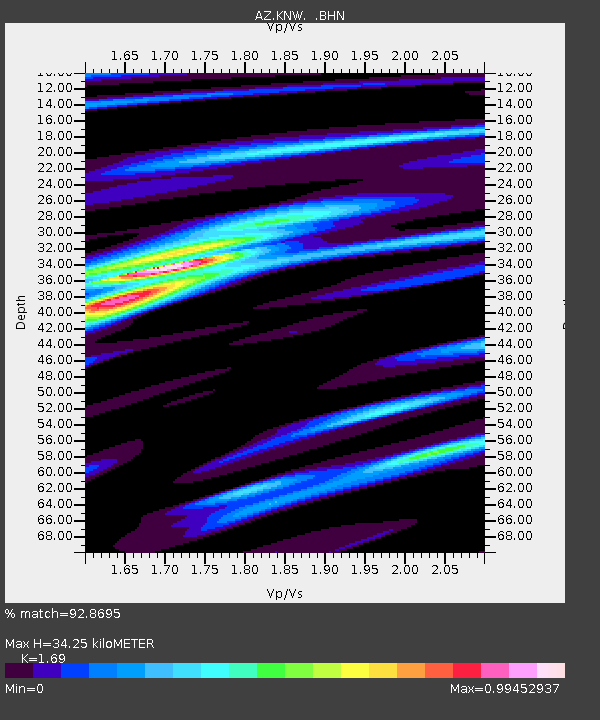
| Estimated Moho Depth: |
34.25 km |
| Estimated Crust Vp/Vs: |
1.69 |
| Assumed Crust Vp: |
6.264 km/s |
| Estimated Crust Vs: |
3.706 km/s |
| Estimated Crust Poisson's Ratio: |
0.23 |
|
| Radial Match: |
92.8695 % |
| Radial Bump: |
383 |
| Transverse Match: |
84.10121 % |
| Transverse Bump: |
400 |
| SOD ConfigId: |
2665 |
| Insert Time: |
2010-02-26 19:35:28.632 +0000 |
| GWidth: |
2.5 |
| Max Bumps: |
400 |
| Tol: |
0.001 |
|
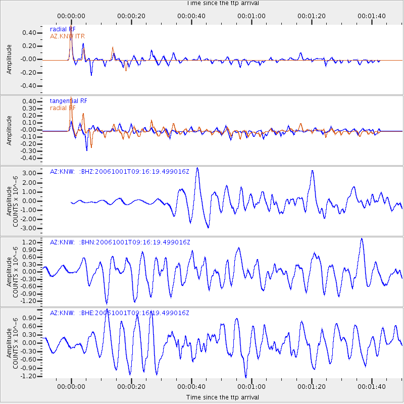
Signal To Noise
| Channel | StoN | STA | LTA |
| AZ:KNW: :BHN:20061001T09:16:19.499016Z | 2.6548393 | 3.5560035E-7 | 1.3394421E-7 |
| AZ:KNW: :BHE:20061001T09:16:19.499016Z | 1.0105422 | 1.4426818E-7 | 1.4276316E-7 |
| AZ:KNW: :BHZ:20061001T09:16:19.499016Z | 4.2104025 | 7.1333517E-7 | 1.6942208E-7 |
| Arrivals |
| Ps | 3.9 SECOND |
| PpPs | 14 SECOND |
| PsPs/PpSs | 18 SECOND |


