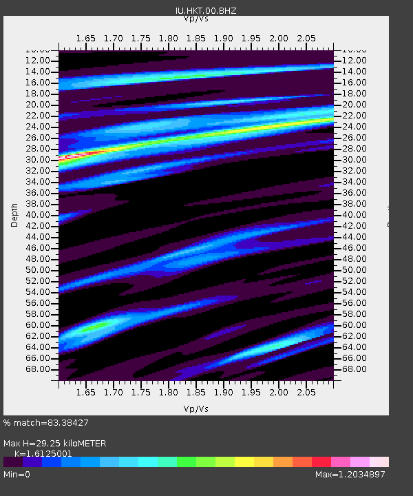
HKT Hockley, Texas - Earthquake Result Viewer
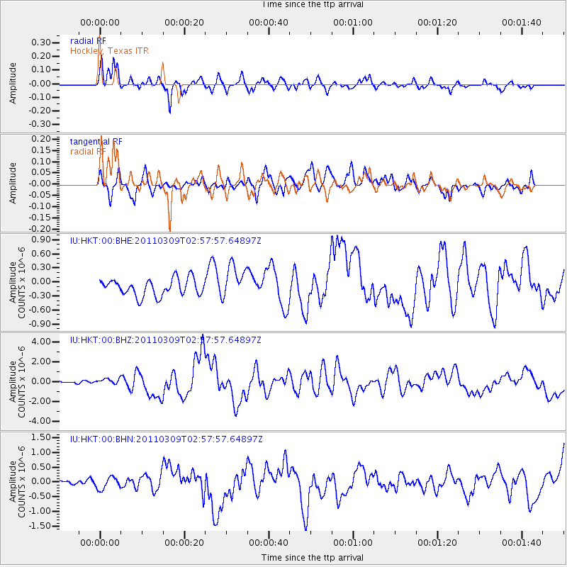
Earthquake location: Near East Coast Of Honshu, Japan
Earthquake latitude/longitude: 38.4/142.8
Earthquake time(UTC): 2011/03/09 (068) 02:45:20 GMT
Earthquake Depth: 32 km
Earthquake Magnitude: 6.4 MB, 7.3 MS, 7.5 MW, 7.3 MW
Earthquake Catalog/Contributor: WHDF/NEIC
Network: IU Global Seismograph Network (GSN - IRIS/USGS)
Station: HKT Hockley, Texas
Lat/Lon: 29.96 N/95.84 W
Elevation: -413.0 m
Distance: 92.7 deg
Az: 47.915 deg
Baz: 317.807 deg
Ray Param: 0.04140145
Estimated Moho Depth: 29.25 km
Estimated Crust Vp/Vs: 1.61
Assumed Crust Vp: 5.581 km/s
Estimated Crust Vs: 3.461 km/s
Estimated Crust Poisson's Ratio: 0.19
Radial Match: 83.38427 %
Radial Bump: 400
Transverse Match: 40.995243 %
Transverse Bump: 400
SOD ConfigId: 354511
Insert Time: 2011-08-09 11:38:50.329 +0000
GWidth: 2.5
Max Bumps: 400
Tol: 0.001

Signal To Noise

ChannelStoNSTALTA
IU:HKT:00:BHZ:20110309T02:57:57.64897Z2.11610032.704667E-71.2781373E-7
IU:HKT:00:BHN:20110309T02:57:57.64897Z1.00013972.2206275E-72.2203172E-7
IU:HKT:00:BHE:20110309T02:57:57.64897Z2.04394943.66629E-71.7937283E-7
Arrivals
Ps3.3 SECOND
PpPs13 SECOND
PsPs/PpSs17 SECOND