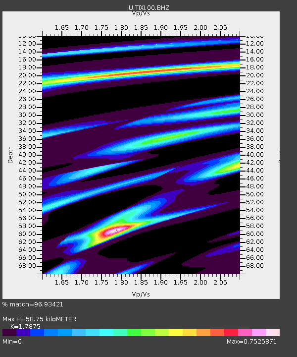
TIXI Tiksi, Russia - Earthquake Result Viewer
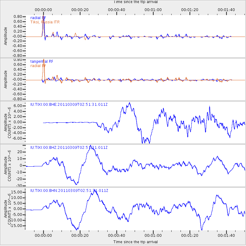
Earthquake location: Near East Coast Of Honshu, Japan
Earthquake latitude/longitude: 38.4/142.8
Earthquake time(UTC): 2011/03/09 (068) 02:45:20 GMT
Earthquake Depth: 32 km
Earthquake Magnitude: 6.4 MB, 7.3 MS, 7.5 MW, 7.3 MW
Earthquake Catalog/Contributor: WHDF/NEIC
Network: IU Global Seismograph Network (GSN - IRIS/USGS)
Station: TIXI Tiksi, Russia
Lat/Lon: 71.63 N/128.87 E
Elevation: 40 m
Distance: 34.0 deg
Az: 352.138 deg
Baz: 160.191 deg
Ray Param: 0.07788311
Estimated Moho Depth: 58.75 km
Estimated Crust Vp/Vs: 1.79
Assumed Crust Vp: 6.552 km/s
Estimated Crust Vs: 3.666 km/s
Estimated Crust Poisson's Ratio: 0.27
Radial Match: 96.93421 %
Radial Bump: 353
Transverse Match: 86.06195 %
Transverse Bump: 400
SOD ConfigId: 354511
Insert Time: 2011-08-09 11:39:57.832 +0000
GWidth: 2.5
Max Bumps: 400
Tol: 0.001

Signal To Noise

ChannelStoNSTALTA
IU:TIXI:00:BHZ:20110309T02:51:31.011Z25.2146115.595062E-62.2189762E-7
IU:TIXI:00:BHN:20110309T02:51:31.011Z18.4468423.4187653E-61.8533066E-7
IU:TIXI:00:BHE:20110309T02:51:31.011Z23.586141.5963461E-66.768153E-8
Arrivals
Ps7.6 SECOND
PpPs23 SECOND
PsPs/PpSs31 SECOND