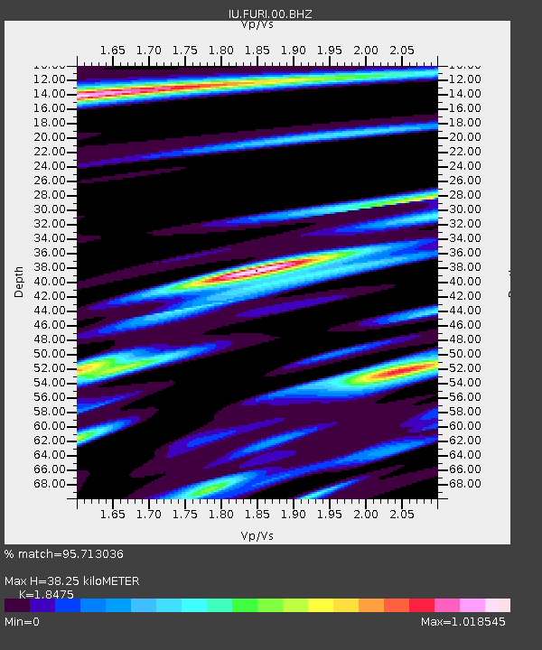
FURI Mt. Furi, Ethiopia - Earthquake Result Viewer
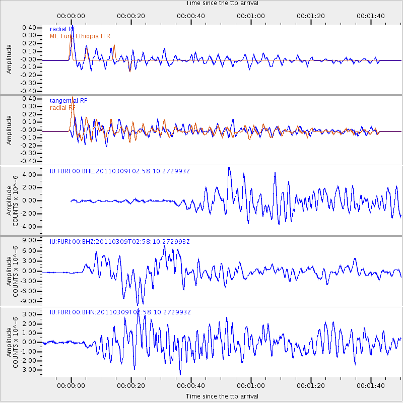
Earthquake location: Near East Coast Of Honshu, Japan
Earthquake latitude/longitude: 38.4/142.8
Earthquake time(UTC): 2011/03/09 (068) 02:45:20 GMT
Earthquake Depth: 32 km
Earthquake Magnitude: 6.4 MB, 7.3 MS, 7.5 MW, 7.3 MW
Earthquake Catalog/Contributor: WHDF/NEIC
Network: IU Global Seismograph Network (GSN - IRIS/USGS)
Station: FURI Mt. Furi, Ethiopia
Lat/Lon: 8.90 N/38.68 E
Elevation: 2570 m
Distance: 95.4 deg
Az: 285.755 deg
Baz: 49.899 deg
Ray Param: 0.04076856
Estimated Moho Depth: 38.25 km
Estimated Crust Vp/Vs: 1.85
Assumed Crust Vp: 6.464 km/s
Estimated Crust Vs: 3.499 km/s
Estimated Crust Poisson's Ratio: 0.29
Radial Match: 95.713036 %
Radial Bump: 400
Transverse Match: 92.04084 %
Transverse Bump: 400
SOD ConfigId: 354511
Insert Time: 2011-08-09 11:41:05.859 +0000
GWidth: 2.5
Max Bumps: 400
Tol: 0.001

Signal To Noise

ChannelStoNSTALTA
IU:FURI:00:BHZ:20110309T02:58:10.272993Z5.55807356.724971E-71.2099464E-7
IU:FURI:00:BHN:20110309T02:58:10.272993Z0.961340079.692731E-81.00825204E-7
IU:FURI:00:BHE:20110309T02:58:10.272993Z0.701530758.959295E-81.2771065E-7
Arrivals
Ps5.1 SECOND
PpPs17 SECOND
PsPs/PpSs22 SECOND