You are here: Home > Network List > IW - Intermountain West Stations List
> Station DLMT Dillon, Montana, USA > Earthquake Result Viewer
DLMT Dillon, Montana, USA - Earthquake Result Viewer
| Earthquake location: |
Near East Coast Of Honshu, Japan |
| Earthquake latitude/longitude: |
38.4/142.8 |
| Earthquake time(UTC): |
2011/03/09 (068) 02:45:20 GMT |
| Earthquake Depth: |
32 km |
| Earthquake Magnitude: |
6.4 MB, 7.3 MS, 7.5 MW, 7.3 MW |
| Earthquake Catalog/Contributor: |
WHDF/NEIC |
|
| Network: |
IW Intermountain West |
| Station: |
DLMT Dillon, Montana, USA |
| Lat/Lon: |
45.36 N/112.60 W |
| Elevation: |
1569 m |
|
| Distance: |
72.6 deg |
| Az: |
45.665 deg |
| Baz: |
307.177 deg |
| Ray Param: |
0.05353934 |
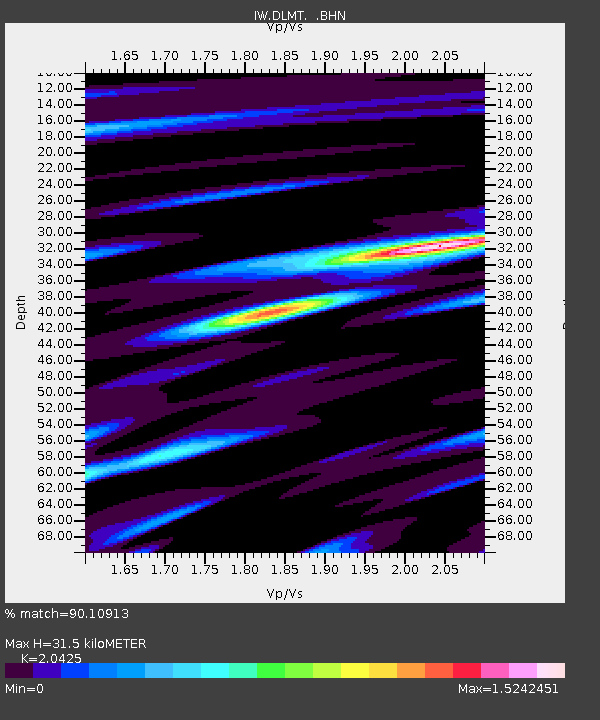
| Estimated Moho Depth: |
31.5 km |
| Estimated Crust Vp/Vs: |
2.04 |
| Assumed Crust Vp: |
6.577 km/s |
| Estimated Crust Vs: |
3.22 km/s |
| Estimated Crust Poisson's Ratio: |
0.34 |
|
| Radial Match: |
90.10913 % |
| Radial Bump: |
400 |
| Transverse Match: |
85.21234 % |
| Transverse Bump: |
400 |
| SOD ConfigId: |
354511 |
| Insert Time: |
2011-08-09 11:44:00.951 +0000 |
| GWidth: |
2.5 |
| Max Bumps: |
400 |
| Tol: |
0.001 |
|

Signal To Noise
| Channel | StoN | STA | LTA |
| IW:DLMT: :BHZ:20110309T02:56:13.21501Z | 2.334605 | 3.4273995E-7 | 1.4680855E-7 |
| IW:DLMT: :BHN:20110309T02:56:13.21501Z | 0.8201651 | 1.7442065E-7 | 2.126653E-7 |
| IW:DLMT: :BHE:20110309T02:56:13.21501Z | 3.2321973 | 5.314557E-7 | 1.6442553E-7 |
| Arrivals |
| Ps | 5.2 SECOND |
| PpPs | 14 SECOND |
| PsPs/PpSs | 19 SECOND |


