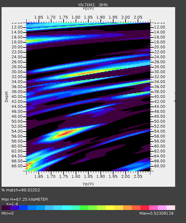
TKM2 KN.TKM2 - Earthquake Result Viewer
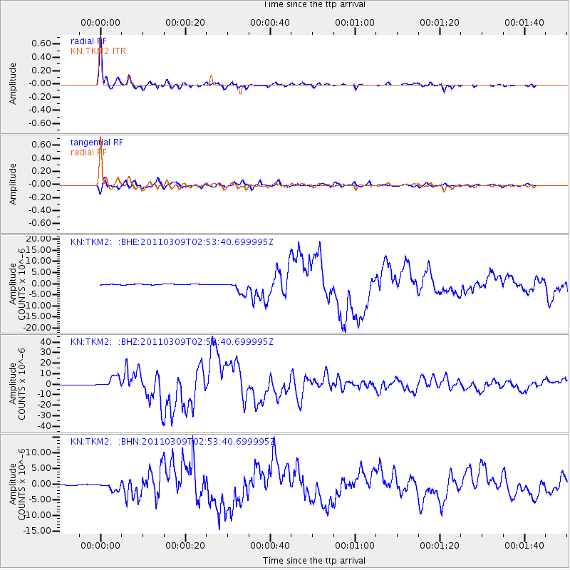
Earthquake location: Near East Coast Of Honshu, Japan
Earthquake latitude/longitude: 38.4/142.8
Earthquake time(UTC): 2011/03/09 (068) 02:45:20 GMT
Earthquake Depth: 32 km
Earthquake Magnitude: 6.4 MB, 7.3 MS, 7.5 MW, 7.3 MW
Earthquake Catalog/Contributor: WHDF/NEIC
Network: KN Kyrgyz Seismic Telemetry Network
Station: TKM2 KN.TKM2
Lat/Lon: 42.92 N/75.60 E
Elevation: 2020 m
Distance: 50.0 deg
Az: 297.789 deg
Baz: 71.052 deg
Ray Param: 0.068302944
Estimated Moho Depth: 67.25 km
Estimated Crust Vp/Vs: 1.60
Assumed Crust Vp: 6.306 km/s
Estimated Crust Vs: 3.941 km/s
Estimated Crust Poisson's Ratio: 0.18
Radial Match: 98.83202 %
Radial Bump: 319
Transverse Match: 96.553116 %
Transverse Bump: 400
SOD ConfigId: 354511
Insert Time: 2011-08-09 11:47:13.754 +0000
GWidth: 2.5
Max Bumps: 400
Tol: 0.001

Signal To Noise

ChannelStoNSTALTA
KN:TKM2: :BHZ:20110309T02:53:40.699995Z29.129995.4780708E-61.8805606E-7
KN:TKM2: :BHN:20110309T02:53:40.699995Z7.7694521.2584603E-61.6197544E-7
KN:TKM2: :BHE:20110309T02:53:40.699995Z19.066882.8637398E-61.5019448E-7
Arrivals
Ps6.8 SECOND
PpPs26 SECOND
PsPs/PpSs33 SECOND