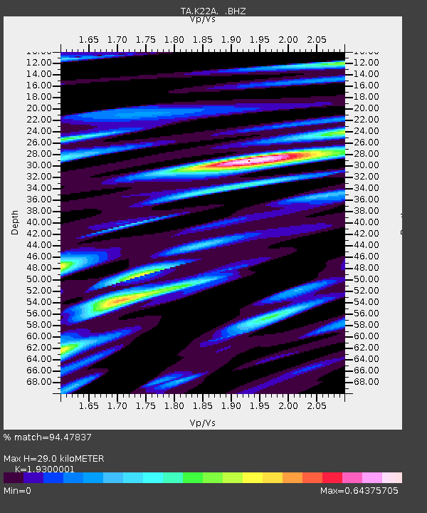
K22A Casper, WY, USA - Earthquake Result Viewer

Earthquake location: Near East Coast Of Honshu, Japan
Earthquake latitude/longitude: 38.4/142.8
Earthquake time(UTC): 2011/03/09 (068) 02:45:20 GMT
Earthquake Depth: 32 km
Earthquake Magnitude: 6.4 MB, 7.3 MS, 7.5 MW, 7.3 MW
Earthquake Catalog/Contributor: WHDF/NEIC
Network: TA USArray Transportable Network (new EarthScope stations)
Station: K22A Casper, WY, USA
Lat/Lon: 42.65 N/106.52 W
Elevation: 1686 m
Distance: 77.7 deg
Az: 44.972 deg
Baz: 311.206 deg
Ray Param: 0.050127868
Estimated Moho Depth: 29.0 km
Estimated Crust Vp/Vs: 1.93
Assumed Crust Vp: 6.178 km/s
Estimated Crust Vs: 3.201 km/s
Estimated Crust Poisson's Ratio: 0.32
Radial Match: 94.47837 %
Radial Bump: 394
Transverse Match: 84.95846 %
Transverse Bump: 400
SOD ConfigId: 354511
Insert Time: 2011-08-09 12:08:04.179 +0000
GWidth: 2.5
Max Bumps: 400
Tol: 0.001

Signal To Noise

ChannelStoNSTALTA
TA:K22A: :BHZ:20110309T02:56:42.549971Z3.189555.804373E-71.8198094E-7
TA:K22A: :BHN:20110309T02:56:42.549971Z2.63636265.328647E-72.0212117E-7
TA:K22A: :BHE:20110309T02:56:42.549971Z1.17821923.8568484E-73.273456E-7
Arrivals
Ps4.5 SECOND
PpPs13 SECOND
PsPs/PpSs18 SECOND