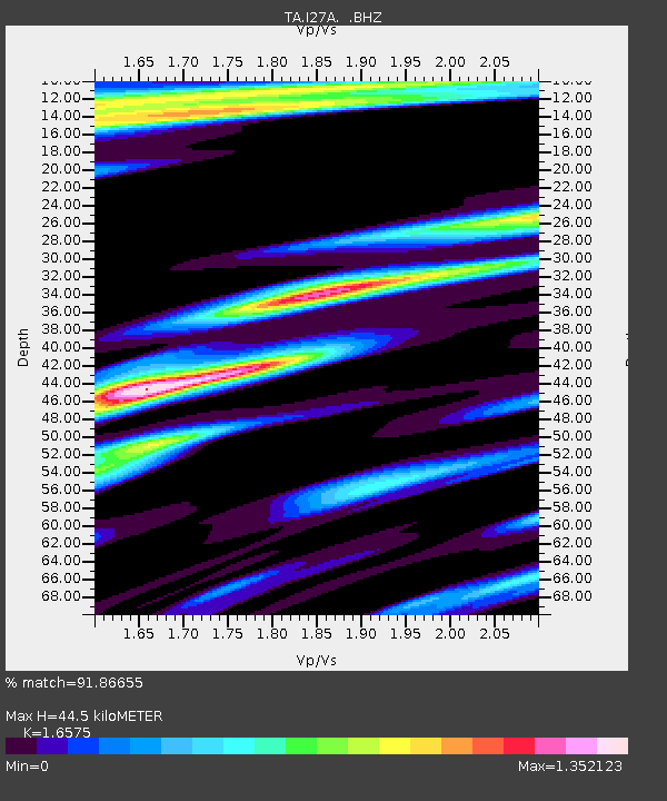
I27A Quinn, SD, USA - Earthquake Result Viewer
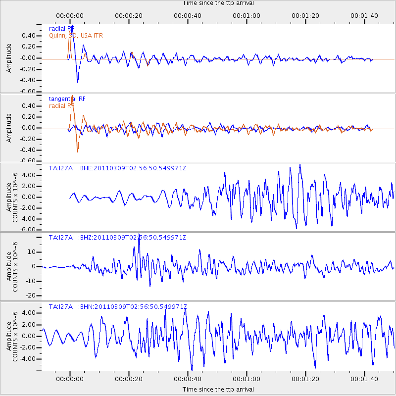
Earthquake location: Near East Coast Of Honshu, Japan
Earthquake latitude/longitude: 38.4/142.8
Earthquake time(UTC): 2011/03/09 (068) 02:45:20 GMT
Earthquake Depth: 32 km
Earthquake Magnitude: 6.4 MB, 7.3 MS, 7.5 MW, 7.3 MW
Earthquake Catalog/Contributor: WHDF/NEIC
Network: TA USArray Transportable Network (new EarthScope stations)
Station: I27A Quinn, SD, USA
Lat/Lon: 44.07 N/102.05 W
Elevation: 867 m
Distance: 79.1 deg
Az: 41.659 deg
Baz: 313.599 deg
Ray Param: 0.04914071
Estimated Moho Depth: 44.5 km
Estimated Crust Vp/Vs: 1.66
Assumed Crust Vp: 6.242 km/s
Estimated Crust Vs: 3.766 km/s
Estimated Crust Poisson's Ratio: 0.21
Radial Match: 91.86655 %
Radial Bump: 400
Transverse Match: 74.49292 %
Transverse Bump: 400
SOD ConfigId: 354511
Insert Time: 2011-08-09 12:23:03.209 +0000
GWidth: 2.5
Max Bumps: 400
Tol: 0.001

Signal To Noise

ChannelStoNSTALTA
TA:I27A: :BHZ:20110309T02:56:50.549971Z3.91756589.231329E-72.356394E-7
TA:I27A: :BHN:20110309T02:56:50.549971Z0.78684515.400772E-76.8638315E-7
TA:I27A: :BHE:20110309T02:56:50.549971Z1.9311439.739962E-75.0436256E-7
Arrivals
Ps4.8 SECOND
PpPs18 SECOND
PsPs/PpSs23 SECOND