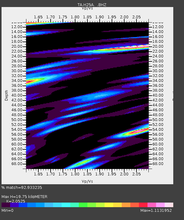
H25A Fruitdale, SD, USA - Earthquake Result Viewer
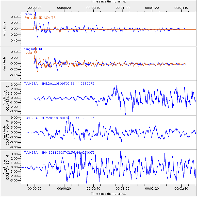
Earthquake location: Near East Coast Of Honshu, Japan
Earthquake latitude/longitude: 38.4/142.8
Earthquake time(UTC): 2011/03/09 (068) 02:45:20 GMT
Earthquake Depth: 32 km
Earthquake Magnitude: 6.4 MB, 7.3 MS, 7.5 MW, 7.3 MW
Earthquake Catalog/Contributor: WHDF/NEIC
Network: TA USArray Transportable Network (new EarthScope stations)
Station: H25A Fruitdale, SD, USA
Lat/Lon: 44.62 N/103.60 W
Elevation: 942 m
Distance: 77.9 deg
Az: 42.021 deg
Baz: 312.594 deg
Ray Param: 0.049946945
Estimated Moho Depth: 19.75 km
Estimated Crust Vp/Vs: 2.05
Assumed Crust Vp: 6.242 km/s
Estimated Crust Vs: 3.041 km/s
Estimated Crust Poisson's Ratio: 0.34
Radial Match: 92.933235 %
Radial Bump: 400
Transverse Match: 80.69602 %
Transverse Bump: 400
SOD ConfigId: 354511
Insert Time: 2011-08-09 12:23:44.561 +0000
GWidth: 2.5
Max Bumps: 400
Tol: 0.001

Signal To Noise

ChannelStoNSTALTA
TA:H25A: :BHZ:20110309T02:56:44.025007Z3.8932956.9584866E-71.7873E-7
TA:H25A: :BHN:20110309T02:56:44.025007Z1.8248323.126895E-71.713525E-7
TA:H25A: :BHE:20110309T02:56:44.025007Z1.37663152.9060064E-72.1109545E-7
Arrivals
Ps3.4 SECOND
PpPs9.4 SECOND
PsPs/PpSs13 SECOND