You are here: Home > Network List > TA - USArray Transportable Network (new EarthScope stations) Stations List
> Station C30A Mose, Pekin, ND, USA > Earthquake Result Viewer
C30A Mose, Pekin, ND, USA - Earthquake Result Viewer
| Earthquake location: |
Near East Coast Of Honshu, Japan |
| Earthquake latitude/longitude: |
38.4/142.8 |
| Earthquake time(UTC): |
2011/03/09 (068) 02:45:20 GMT |
| Earthquake Depth: |
32 km |
| Earthquake Magnitude: |
6.4 MB, 7.3 MS, 7.5 MW, 7.3 MW |
| Earthquake Catalog/Contributor: |
WHDF/NEIC |
|
| Network: |
TA USArray Transportable Network (new EarthScope stations) |
| Station: |
C30A Mose, Pekin, ND, USA |
| Lat/Lon: |
47.70 N/98.48 W |
| Elevation: |
480 m |
|
| Distance: |
78.4 deg |
| Az: |
37.232 deg |
| Baz: |
315.293 deg |
| Ray Param: |
0.049657457 |
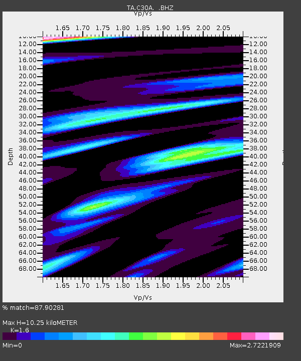
| Estimated Moho Depth: |
10.25 km |
| Estimated Crust Vp/Vs: |
1.60 |
| Assumed Crust Vp: |
6.53 km/s |
| Estimated Crust Vs: |
4.082 km/s |
| Estimated Crust Poisson's Ratio: |
0.18 |
|
| Radial Match: |
87.90281 % |
| Radial Bump: |
400 |
| Transverse Match: |
67.89652 % |
| Transverse Bump: |
400 |
| SOD ConfigId: |
354511 |
| Insert Time: |
2011-08-09 12:26:55.793 +0000 |
| GWidth: |
2.5 |
| Max Bumps: |
400 |
| Tol: |
0.001 |
|

Signal To Noise
| Channel | StoN | STA | LTA |
| TA:C30A: :BHZ:20110309T02:56:46.374983Z | 3.268805 | 9.837294E-7 | 3.0094466E-7 |
| TA:C30A: :BHN:20110309T02:56:46.374983Z | 2.11999 | 1.1029921E-6 | 5.202817E-7 |
| TA:C30A: :BHE:20110309T02:56:46.374983Z | 0.9031911 | 5.415391E-7 | 5.995842E-7 |
| Arrivals |
| Ps | 1.0 SECOND |
| PpPs | 3.9 SECOND |
| PsPs/PpSs | 4.9 SECOND |


