You are here: Home > Network List > TA - USArray Transportable Network (new EarthScope stations) Stations List
> Station Q36A Arnold C. Orvedal, Lecompton, KS, USA > Earthquake Result Viewer
Q36A Arnold C. Orvedal, Lecompton, KS, USA - Earthquake Result Viewer
| Earthquake location: |
Near East Coast Of Honshu, Japan |
| Earthquake latitude/longitude: |
38.7/143.0 |
| Earthquake time(UTC): |
2011/03/09 (068) 04:37:04 GMT |
| Earthquake Depth: |
38 km |
| Earthquake Magnitude: |
5.6 MB |
| Earthquake Catalog/Contributor: |
WHDF/NEIC |
|
| Network: |
TA USArray Transportable Network (new EarthScope stations) |
| Station: |
Q36A Arnold C. Orvedal, Lecompton, KS, USA |
| Lat/Lon: |
38.96 N/95.46 W |
| Elevation: |
306 m |
|
| Distance: |
86.0 deg |
| Az: |
41.763 deg |
| Baz: |
318.025 deg |
| Ray Param: |
0.0443324 |
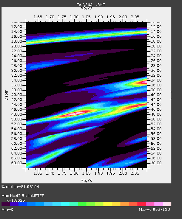
| Estimated Moho Depth: |
47.5 km |
| Estimated Crust Vp/Vs: |
1.80 |
| Assumed Crust Vp: |
6.498 km/s |
| Estimated Crust Vs: |
3.605 km/s |
| Estimated Crust Poisson's Ratio: |
0.28 |
|
| Radial Match: |
81.98194 % |
| Radial Bump: |
400 |
| Transverse Match: |
62.62923 % |
| Transverse Bump: |
367 |
| SOD ConfigId: |
354511 |
| Insert Time: |
2011-08-09 13:20:02.947 +0000 |
| GWidth: |
2.5 |
| Max Bumps: |
400 |
| Tol: |
0.001 |
|
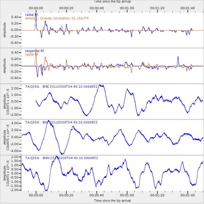
Signal To Noise
| Channel | StoN | STA | LTA |
| TA:Q36A: :BHZ:20110309T04:49:10.099985Z | 2.4292939 | 2.8987477E-6 | 1.193247E-6 |
| TA:Q36A: :BHN:20110309T04:49:10.099985Z | 1.3178585 | 8.6313366E-7 | 6.549517E-7 |
| TA:Q36A: :BHE:20110309T04:49:10.099985Z | 3.0514984 | 1.7537933E-6 | 5.7473187E-7 |
| Arrivals |
| Ps | 6.0 SECOND |
| PpPs | 20 SECOND |
| PsPs/PpSs | 26 SECOND |


