You are here: Home > Network List > TA - USArray Transportable Network (new EarthScope stations) Stations List
> Station U39A Green Forest, AR, USA > Earthquake Result Viewer
U39A Green Forest, AR, USA - Earthquake Result Viewer
| Earthquake location: |
Near East Coast Of Honshu, Japan |
| Earthquake latitude/longitude: |
38.7/143.0 |
| Earthquake time(UTC): |
2011/03/09 (068) 04:37:04 GMT |
| Earthquake Depth: |
38 km |
| Earthquake Magnitude: |
5.6 MB |
| Earthquake Catalog/Contributor: |
WHDF/NEIC |
|
| Network: |
TA USArray Transportable Network (new EarthScope stations) |
| Station: |
U39A Green Forest, AR, USA |
| Lat/Lon: |
36.38 N/93.48 W |
| Elevation: |
433 m |
|
| Distance: |
88.9 deg |
| Az: |
42.285 deg |
| Baz: |
319.254 deg |
| Ray Param: |
0.04216254 |
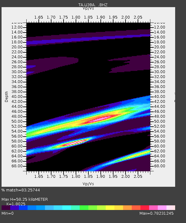
| Estimated Moho Depth: |
58.25 km |
| Estimated Crust Vp/Vs: |
1.80 |
| Assumed Crust Vp: |
6.53 km/s |
| Estimated Crust Vs: |
3.623 km/s |
| Estimated Crust Poisson's Ratio: |
0.28 |
|
| Radial Match: |
83.25744 % |
| Radial Bump: |
400 |
| Transverse Match: |
70.621 % |
| Transverse Bump: |
400 |
| SOD ConfigId: |
354511 |
| Insert Time: |
2011-08-09 13:26:14.399 +0000 |
| GWidth: |
2.5 |
| Max Bumps: |
400 |
| Tol: |
0.001 |
|

Signal To Noise
| Channel | StoN | STA | LTA |
| TA:U39A: :BHZ:20110309T04:49:24.349985Z | 1.6976264 | 3.3509245E-6 | 1.9738882E-6 |
| TA:U39A: :BHN:20110309T04:49:24.349985Z | 1.8836164 | 1.234088E-6 | 6.551695E-7 |
| TA:U39A: :BHE:20110309T04:49:24.349985Z | 0.63205093 | 6.039025E-7 | 9.55465E-7 |
| Arrivals |
| Ps | 7.3 SECOND |
| PpPs | 24 SECOND |
| PsPs/PpSs | 32 SECOND |


