You are here: Home > Network List > XJ13 - CRAFTI Stations List
> Station PR61 Kiloki Boma > Earthquake Result Viewer
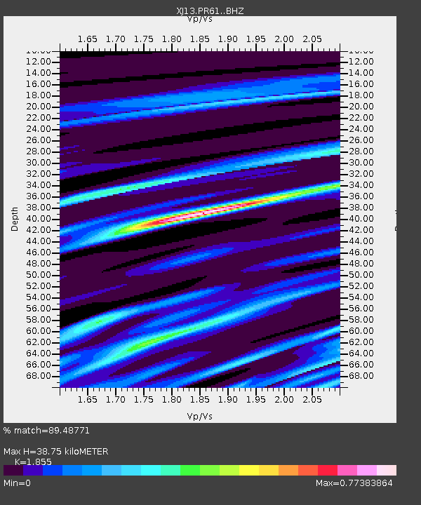
PR61 Kiloki Boma - Earthquake Result Viewer
| Earthquake location: |
Greece |
| Earthquake latitude/longitude: |
38.2/20.5 |
| Earthquake time(UTC): |
2014/01/26 (026) 13:55:42 GMT |
| Earthquake Depth: |
8.0 km |
| Earthquake Magnitude: |
6.1 MWW, 6.1 MWB, 6.2 MWC |
| Earthquake Catalog/Contributor: |
NEIC PDE/NEIC COMCAT |
|
| Network: |
XJ CRAFTI |
| Station: |
PR61 Kiloki Boma |
| Lat/Lon: |
2.96 S/35.25 E |
| Elevation: |
1549 m |
|
| Distance: |
43.2 deg |
| Az: |
158.123 deg |
| Baz: |
342.907 deg |
| Ray Param: |
0.072716944 |
| Estimated Moho Depth: |
38.75 km |
| Estimated Crust Vp/Vs: |
1.86 |
| Assumed Crust Vp: |
6.576 km/s |
| Estimated Crust Vs: |
3.545 km/s |
| Estimated Crust Poisson's Ratio: |
0.30 |
|
| Radial Match: |
89.48771 % |
| Radial Bump: |
400 |
| Transverse Match: |
64.629555 % |
| Transverse Bump: |
400 |
| SOD ConfigId: |
3390531 |
| Insert Time: |
2019-04-10 03:13:03.791 +0000 |
| GWidth: |
2.5 |
| Max Bumps: |
400 |
| Tol: |
0.001 |
|

Signal To Noise
| Channel | StoN | STA | LTA |
| XJ:PR61: :BHZ:20140126T14:03:12.560006Z | 4.207841 | 2.9308038E-7 | 6.9651016E-8 |
| XJ:PR61: :BHN:20140126T14:03:12.560006Z | 2.9918466 | 1.627498E-7 | 5.4397777E-8 |
| XJ:PR61: :BHE:20140126T14:03:12.560006Z | 1.9361196 | 1.2229192E-7 | 6.316342E-8 |
| Arrivals |
| Ps | 5.4 SECOND |
| PpPs | 16 SECOND |
| PsPs/PpSs | 21 SECOND |


