You are here: Home > Network List > XJ13 - CRAFTI Stations List
> Station PR63 Meshili Boma > Earthquake Result Viewer
PR63 Meshili Boma - Earthquake Result Viewer
| Earthquake location: |
Greece |
| Earthquake latitude/longitude: |
38.2/20.5 |
| Earthquake time(UTC): |
2014/01/26 (026) 13:55:42 GMT |
| Earthquake Depth: |
8.0 km |
| Earthquake Magnitude: |
6.1 MWW, 6.1 MWB, 6.2 MWC |
| Earthquake Catalog/Contributor: |
NEIC PDE/NEIC COMCAT |
|
| Network: |
XJ CRAFTI |
| Station: |
PR63 Meshili Boma |
| Lat/Lon: |
2.99 S/35.51 E |
| Elevation: |
1362 m |
|
| Distance: |
43.3 deg |
| Az: |
157.778 deg |
| Baz: |
342.642 deg |
| Ray Param: |
0.07264658 |
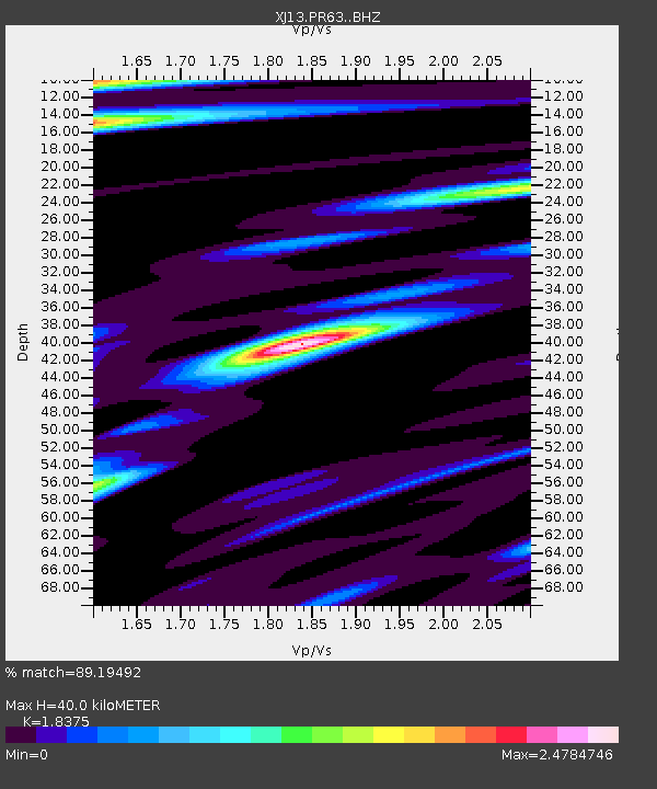
| Estimated Moho Depth: |
40.0 km |
| Estimated Crust Vp/Vs: |
1.84 |
| Assumed Crust Vp: |
6.576 km/s |
| Estimated Crust Vs: |
3.579 km/s |
| Estimated Crust Poisson's Ratio: |
0.29 |
|
| Radial Match: |
89.19492 % |
| Radial Bump: |
354 |
| Transverse Match: |
80.37962 % |
| Transverse Bump: |
365 |
| SOD ConfigId: |
3390531 |
| Insert Time: |
2019-04-10 03:13:04.607 +0000 |
| GWidth: |
2.5 |
| Max Bumps: |
400 |
| Tol: |
0.001 |
|

Signal To Noise
| Channel | StoN | STA | LTA |
| XJ:PR63: :BHZ:20140126T14:03:13.440011Z | 4.5344725 | 3.8519846E-7 | 8.49489E-8 |
| XJ:PR63: :BHN:20140126T14:03:13.440011Z | 1.9418335 | 1.7830845E-7 | 9.1824795E-8 |
| XJ:PR63: :BHE:20140126T14:03:13.440011Z | 0.80200016 | 9.322709E-8 | 1.1624323E-7 |
| Arrivals |
| Ps | 5.4 SECOND |
| PpPs | 16 SECOND |
| PsPs/PpSs | 22 SECOND |


