You are here: Home > Network List > IW - Intermountain West Stations List
> Station DLMT Dillon, Montana, USA > Earthquake Result Viewer
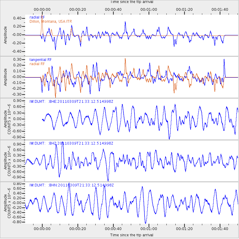
DLMT Dillon, Montana, USA - Earthquake Result Viewer
*The percent match for this event was below the threshold and hence no stack was calculated.
| Earthquake location: |
Near East Coast Of Honshu, Japan |
| Earthquake latitude/longitude: |
38.3/142.6 |
| Earthquake time(UTC): |
2011/03/09 (068) 21:22:17 GMT |
| Earthquake Depth: |
23 km |
| Earthquake Magnitude: |
5.9 MB, 5.9 ME |
| Earthquake Catalog/Contributor: |
WHDF/NEIC |
|
| Network: |
IW Intermountain West |
| Station: |
DLMT Dillon, Montana, USA |
| Lat/Lon: |
45.36 N/112.60 W |
| Elevation: |
1569 m |
|
| Distance: |
72.7 deg |
| Az: |
45.558 deg |
| Baz: |
307.221 deg |
| Ray Param: |
$rayparam |
*The percent match for this event was below the threshold and hence was not used in the summary stack. |
|
| Radial Match: |
58.067047 % |
| Radial Bump: |
400 |
| Transverse Match: |
58.02776 % |
| Transverse Bump: |
400 |
| SOD ConfigId: |
354511 |
| Insert Time: |
2011-08-09 14:18:06.305 +0000 |
| GWidth: |
2.5 |
| Max Bumps: |
400 |
| Tol: |
0.001 |
|
Signal To Noise
| Channel | StoN | STA | LTA |
| IW:DLMT: :BHZ:20110309T21:33:12.514998Z | 1.9288377 | 2.5151516E-7 | 1.3039727E-7 |
| IW:DLMT: :BHN:20110309T21:33:12.514998Z | 1.08191 | 2.2655321E-7 | 2.0940116E-7 |
| IW:DLMT: :BHE:20110309T21:33:12.514998Z | 1.7704746 | 4.1934717E-7 | 2.3685581E-7 |
| Arrivals |
| Ps | |
| PpPs | |
| PsPs/PpSs | |


