You are here: Home > Network List > TA - USArray Transportable Network (new EarthScope stations) Stations List
> Station S30A Montezuma, KS, USA > Earthquake Result Viewer
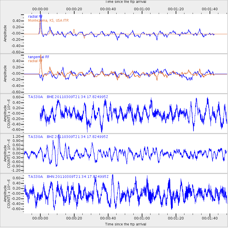
S30A Montezuma, KS, USA - Earthquake Result Viewer
*The percent match for this event was below the threshold and hence no stack was calculated.
| Earthquake location: |
Near East Coast Of Honshu, Japan |
| Earthquake latitude/longitude: |
38.3/142.6 |
| Earthquake time(UTC): |
2011/03/09 (068) 21:22:17 GMT |
| Earthquake Depth: |
23 km |
| Earthquake Magnitude: |
5.9 MB, 5.9 ME |
| Earthquake Catalog/Contributor: |
WHDF/NEIC |
|
| Network: |
TA USArray Transportable Network (new EarthScope stations) |
| Station: |
S30A Montezuma, KS, USA |
| Lat/Lon: |
37.64 N/100.46 W |
| Elevation: |
853 m |
|
| Distance: |
84.6 deg |
| Az: |
45.327 deg |
| Baz: |
315.22 deg |
| Ray Param: |
$rayparam |
*The percent match for this event was below the threshold and hence was not used in the summary stack. |
|
| Radial Match: |
69.899765 % |
| Radial Bump: |
375 |
| Transverse Match: |
62.981926 % |
| Transverse Bump: |
400 |
| SOD ConfigId: |
354511 |
| Insert Time: |
2011-08-09 14:28:12.887 +0000 |
| GWidth: |
2.5 |
| Max Bumps: |
400 |
| Tol: |
0.001 |
|
Signal To Noise
| Channel | StoN | STA | LTA |
| TA:S30A: :BHZ:20110309T21:34:17.824995Z | 2.3032024 | 3.090842E-7 | 1.3419758E-7 |
| TA:S30A: :BHN:20110309T21:34:17.824995Z | 1.2467072 | 1.7965364E-7 | 1.4410251E-7 |
| TA:S30A: :BHE:20110309T21:34:17.824995Z | 1.2253884 | 2.3075039E-7 | 1.8830795E-7 |
| Arrivals |
| Ps | |
| PpPs | |
| PsPs/PpSs | |


