You are here: Home > Network List > TA - USArray Transportable Network (new EarthScope stations) Stations List
> Station X33A Lawton, OK, USA > Earthquake Result Viewer
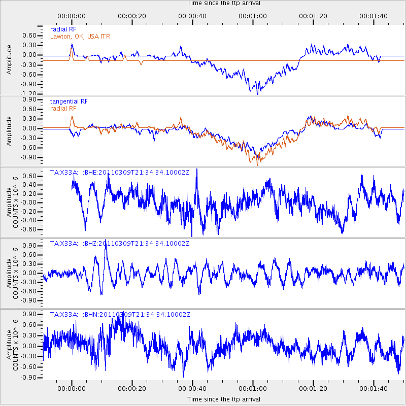
X33A Lawton, OK, USA - Earthquake Result Viewer
*The percent match for this event was below the threshold and hence no stack was calculated.
| Earthquake location: |
Near East Coast Of Honshu, Japan |
| Earthquake latitude/longitude: |
38.3/142.6 |
| Earthquake time(UTC): |
2011/03/09 (068) 21:22:17 GMT |
| Earthquake Depth: |
23 km |
| Earthquake Magnitude: |
5.9 MB, 5.9 ME |
| Earthquake Catalog/Contributor: |
WHDF/NEIC |
|
| Network: |
TA USArray Transportable Network (new EarthScope stations) |
| Station: |
X33A Lawton, OK, USA |
| Lat/Lon: |
34.54 N/98.50 W |
| Elevation: |
346 m |
|
| Distance: |
88.0 deg |
| Az: |
46.343 deg |
| Baz: |
316.438 deg |
| Ray Param: |
$rayparam |
*The percent match for this event was below the threshold and hence was not used in the summary stack. |
|
| Radial Match: |
57.942497 % |
| Radial Bump: |
400 |
| Transverse Match: |
63.321274 % |
| Transverse Bump: |
400 |
| SOD ConfigId: |
354511 |
| Insert Time: |
2011-08-09 14:36:58.424 +0000 |
| GWidth: |
2.5 |
| Max Bumps: |
400 |
| Tol: |
0.001 |
|
Signal To Noise
| Channel | StoN | STA | LTA |
| TA:X33A: :BHZ:20110309T21:34:34.10002Z | 0.7460536 | 1.0540305E-7 | 1.4128081E-7 |
| TA:X33A: :BHN:20110309T21:34:34.10002Z | 1.5088052 | 9.655132E-7 | 6.3991905E-7 |
| TA:X33A: :BHE:20110309T21:34:34.10002Z | 1.2156684 | 2.815612E-7 | 2.3161019E-7 |
| Arrivals |
| Ps | |
| PpPs | |
| PsPs/PpSs | |


