You are here: Home > Network List > TA - USArray Transportable Network (new EarthScope stations) Stations List
> Station L37A Phoenix Point, Boone, IA, USA > Earthquake Result Viewer
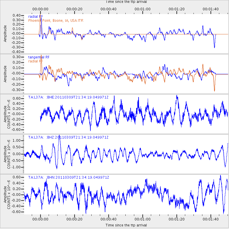
L37A Phoenix Point, Boone, IA, USA - Earthquake Result Viewer
*The percent match for this event was below the threshold and hence no stack was calculated.
| Earthquake location: |
Near East Coast Of Honshu, Japan |
| Earthquake latitude/longitude: |
38.3/142.6 |
| Earthquake time(UTC): |
2011/03/09 (068) 21:22:17 GMT |
| Earthquake Depth: |
23 km |
| Earthquake Magnitude: |
5.9 MB, 5.9 ME |
| Earthquake Catalog/Contributor: |
WHDF/NEIC |
|
| Network: |
TA USArray Transportable Network (new EarthScope stations) |
| Station: |
L37A Phoenix Point, Boone, IA, USA |
| Lat/Lon: |
42.12 N/93.75 W |
| Elevation: |
312 m |
|
| Distance: |
84.9 deg |
| Az: |
38.472 deg |
| Baz: |
318.885 deg |
| Ray Param: |
$rayparam |
*The percent match for this event was below the threshold and hence was not used in the summary stack. |
|
| Radial Match: |
52.631325 % |
| Radial Bump: |
400 |
| Transverse Match: |
34.2876 % |
| Transverse Bump: |
343 |
| SOD ConfigId: |
356183 |
| Insert Time: |
2011-08-09 15:35:49.952 +0000 |
| GWidth: |
2.5 |
| Max Bumps: |
400 |
| Tol: |
0.001 |
|
Signal To Noise
| Channel | StoN | STA | LTA |
| TA:L37A: :BHZ:20110309T21:34:19.049971Z | 2.0934894 | 2.8767843E-7 | 1.3741574E-7 |
| TA:L37A: :BHN:20110309T21:34:19.049971Z | 1.3528621 | 2.7724906E-7 | 2.0493519E-7 |
| TA:L37A: :BHE:20110309T21:34:19.049971Z | 1.9872885 | 3.3417544E-7 | 1.6815648E-7 |
| Arrivals |
| Ps | |
| PpPs | |
| PsPs/PpSs | |


