You are here: Home > Network List > KN - Kyrgyz Seismic Telemetry Network Stations List
> Station EKS2 KN.EKS2 > Earthquake Result Viewer
EKS2 KN.EKS2 - Earthquake Result Viewer
| Earthquake location: |
Near East Coast Of Honshu, Japan |
| Earthquake latitude/longitude: |
38.3/142.8 |
| Earthquake time(UTC): |
2011/03/09 (068) 21:24:01 GMT |
| Earthquake Depth: |
15 km |
| Earthquake Magnitude: |
6.0 MB, 6.4 MS |
| Earthquake Catalog/Contributor: |
WHDF/NEIC |
|
| Network: |
KN Kyrgyz Seismic Telemetry Network |
| Station: |
EKS2 KN.EKS2 |
| Lat/Lon: |
42.66 N/73.78 E |
| Elevation: |
1360 m |
|
| Distance: |
51.4 deg |
| Az: |
298.138 deg |
| Baz: |
70.159 deg |
| Ray Param: |
0.06745071 |
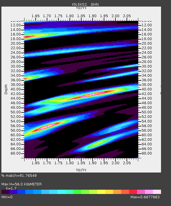
| Estimated Moho Depth: |
56.0 km |
| Estimated Crust Vp/Vs: |
1.70 |
| Assumed Crust Vp: |
6.316 km/s |
| Estimated Crust Vs: |
3.715 km/s |
| Estimated Crust Poisson's Ratio: |
0.24 |
|
| Radial Match: |
91.76549 % |
| Radial Bump: |
400 |
| Transverse Match: |
81.545074 % |
| Transverse Bump: |
400 |
| SOD ConfigId: |
356183 |
| Insert Time: |
2011-08-09 15:56:43.309 +0000 |
| GWidth: |
2.5 |
| Max Bumps: |
400 |
| Tol: |
0.001 |
|

Signal To Noise
| Channel | StoN | STA | LTA |
| KN:EKS2: :BHZ:20110309T21:32:34.524971Z | 3.8755903 | 1.5308617E-6 | 3.950009E-7 |
| KN:EKS2: :BHN:20110309T21:32:34.524971Z | 1.3684815 | 5.216363E-7 | 3.811789E-7 |
| KN:EKS2: :BHE:20110309T21:32:34.524971Z | 1.9627821 | 5.0153454E-7 | 2.5552228E-7 |
| Arrivals |
| Ps | 6.6 SECOND |
| PpPs | 23 SECOND |
| PsPs/PpSs | 29 SECOND |


