You are here: Home > Network List > US - United States National Seismic Network Stations List
> Station MIAR Mount Ida, Arkansas, USA > Earthquake Result Viewer
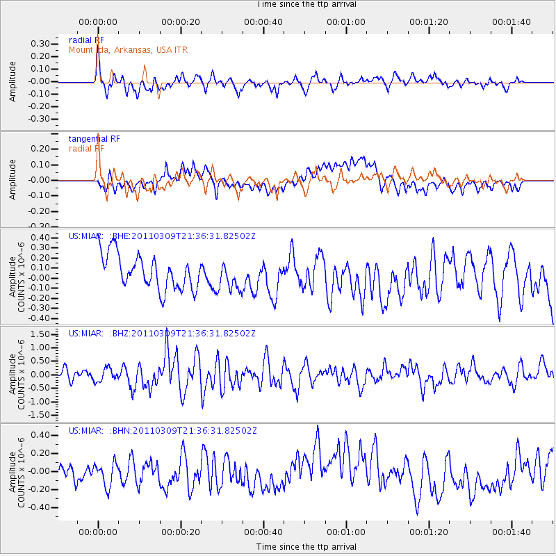
MIAR Mount Ida, Arkansas, USA - Earthquake Result Viewer
*The percent match for this event was below the threshold and hence no stack was calculated.
| Earthquake location: |
Near East Coast Of Honshu, Japan |
| Earthquake latitude/longitude: |
38.3/142.8 |
| Earthquake time(UTC): |
2011/03/09 (068) 21:24:01 GMT |
| Earthquake Depth: |
15 km |
| Earthquake Magnitude: |
6.0 MB, 6.4 MS |
| Earthquake Catalog/Contributor: |
WHDF/NEIC |
|
| Network: |
US United States National Seismic Network |
| Station: |
MIAR Mount Ida, Arkansas, USA |
| Lat/Lon: |
34.55 N/93.58 W |
| Elevation: |
207 m |
|
| Distance: |
90.6 deg |
| Az: |
43.429 deg |
| Baz: |
319.058 deg |
| Ray Param: |
$rayparam |
*The percent match for this event was below the threshold and hence was not used in the summary stack. |
|
| Radial Match: |
73.10638 % |
| Radial Bump: |
400 |
| Transverse Match: |
39.690777 % |
| Transverse Bump: |
400 |
| SOD ConfigId: |
356183 |
| Insert Time: |
2011-08-09 16:12:50.634 +0000 |
| GWidth: |
2.5 |
| Max Bumps: |
400 |
| Tol: |
0.001 |
|
Signal To Noise
| Channel | StoN | STA | LTA |
| US:MIAR: :BHZ:20110309T21:36:31.82502Z | 1.2762713 | 2.4294872E-7 | 1.9035821E-7 |
| US:MIAR: :BHN:20110309T21:36:31.82502Z | 1.3143548 | 1.6184246E-7 | 1.2313454E-7 |
| US:MIAR: :BHE:20110309T21:36:31.82502Z | 0.8351774 | 1.4102618E-7 | 1.6885775E-7 |
| Arrivals |
| Ps | |
| PpPs | |
| PsPs/PpSs | |


