You are here: Home > Network List > US - United States National Seismic Network Stations List
> Station WMOK Wichita Mountains, Oklahoma, USA > Earthquake Result Viewer
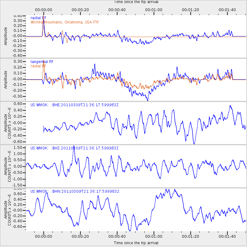
WMOK Wichita Mountains, Oklahoma, USA - Earthquake Result Viewer
*The percent match for this event was below the threshold and hence no stack was calculated.
| Earthquake location: |
Near East Coast Of Honshu, Japan |
| Earthquake latitude/longitude: |
38.3/142.8 |
| Earthquake time(UTC): |
2011/03/09 (068) 21:24:01 GMT |
| Earthquake Depth: |
15 km |
| Earthquake Magnitude: |
6.0 MB, 6.4 MS |
| Earthquake Catalog/Contributor: |
WHDF/NEIC |
|
| Network: |
US United States National Seismic Network |
| Station: |
WMOK Wichita Mountains, Oklahoma, USA |
| Lat/Lon: |
34.74 N/98.78 W |
| Elevation: |
486 m |
|
| Distance: |
87.6 deg |
| Az: |
46.468 deg |
| Baz: |
316.158 deg |
| Ray Param: |
$rayparam |
*The percent match for this event was below the threshold and hence was not used in the summary stack. |
|
| Radial Match: |
37.887264 % |
| Radial Bump: |
400 |
| Transverse Match: |
23.848196 % |
| Transverse Bump: |
400 |
| SOD ConfigId: |
356183 |
| Insert Time: |
2011-08-09 16:12:51.167 +0000 |
| GWidth: |
2.5 |
| Max Bumps: |
400 |
| Tol: |
0.001 |
|
Signal To Noise
| Channel | StoN | STA | LTA |
| US:WMOK: :BHZ:20110309T21:36:17.599983Z | 0.7116342 | 1.0663426E-7 | 1.498442E-7 |
| US:WMOK: :BHN:20110309T21:36:17.599983Z | 3.1629698 | 6.630883E-7 | 2.0964104E-7 |
| US:WMOK: :BHE:20110309T21:36:17.599983Z | 3.5464268 | 3.0472597E-7 | 8.5924796E-8 |
| Arrivals |
| Ps | |
| PpPs | |
| PsPs/PpSs | |


