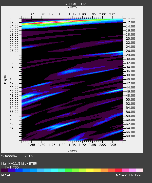
XMI Christmas Island Airport - Earthquake Result Viewer

Earthquake location: New Britain Region, P.N.G.
Earthquake latitude/longitude: -6.0/149.8
Earthquake time(UTC): 2011/03/09 (068) 21:24:49 GMT
Earthquake Depth: 29 km
Earthquake Magnitude: 5.9 MB, 6.5 MS, 6.3 MW, 6.4 MW
Earthquake Catalog/Contributor: WHDF/NEIC
Network: AU Australian Seismological Centre
Station: XMI Christmas Island Airport
Lat/Lon: 10.45 S/105.69 E
Elevation: 252 m
Distance: 43.8 deg
Az: 261.191 deg
Baz: 87.778 deg
Ray Param: 0.07224009
Estimated Moho Depth: 11.5 km
Estimated Crust Vp/Vs: 1.76
Assumed Crust Vp: 4.157 km/s
Estimated Crust Vs: 2.355 km/s
Estimated Crust Poisson's Ratio: 0.26
Radial Match: 83.82816 %
Radial Bump: 329
Transverse Match: 74.04582 %
Transverse Bump: 400
SOD ConfigId: 356183
Insert Time: 2011-08-09 16:22:09.974 +0000
GWidth: 2.5
Max Bumps: 400
Tol: 0.001

Signal To Noise

ChannelStoNSTALTA
AU:XMI: :BHZ:20110309T21:32:22.545004Z2.06396872.7612105E-61.337816E-6
AU:XMI: :BHN:20110309T21:32:22.545004Z0.718157657.1493554E-79.955133E-7
AU:XMI: :BHE:20110309T21:32:22.545004Z1.45179071.6914215E-61.1650587E-6
Arrivals
Ps2.2 SECOND
PpPs7.5 SECOND
PsPs/PpSs9.6 SECOND