You are here: Home > Network List > TA - USArray Transportable Network (new EarthScope stations) Stations List
> Station 334A Lometa, TX, USA > Earthquake Result Viewer
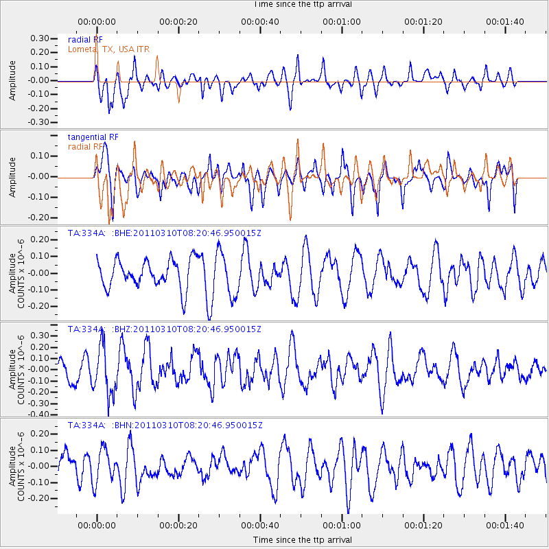
334A Lometa, TX, USA - Earthquake Result Viewer
*The percent match for this event was below the threshold and hence no stack was calculated.
| Earthquake location: |
Off East Coast Of Honshu, Japan |
| Earthquake latitude/longitude: |
38.6/143.3 |
| Earthquake time(UTC): |
2011/03/10 (069) 08:08:20 GMT |
| Earthquake Depth: |
17 km |
| Earthquake Magnitude: |
5.7 MW, 5.3 MS, 5.4 MB, 5.6 MW |
| Earthquake Catalog/Contributor: |
WHDF/NEIC |
|
| Network: |
TA USArray Transportable Network (new EarthScope stations) |
| Station: |
334A Lometa, TX, USA |
| Lat/Lon: |
31.33 N/98.24 W |
| Elevation: |
389 m |
|
| Distance: |
89.9 deg |
| Az: |
48.77 deg |
| Baz: |
316.478 deg |
| Ray Param: |
$rayparam |
*The percent match for this event was below the threshold and hence was not used in the summary stack. |
|
| Radial Match: |
43.427208 % |
| Radial Bump: |
400 |
| Transverse Match: |
51.35312 % |
| Transverse Bump: |
400 |
| SOD ConfigId: |
356183 |
| Insert Time: |
2011-08-09 17:01:59.527 +0000 |
| GWidth: |
2.5 |
| Max Bumps: |
400 |
| Tol: |
0.001 |
|
Signal To Noise
| Channel | StoN | STA | LTA |
| TA:334A: :BHZ:20110310T08:20:46.950015Z | 1.7681957 | 2.1528528E-7 | 1.2175421E-7 |
| TA:334A: :BHN:20110310T08:20:46.950015Z | 1.0943849 | 1.0590195E-7 | 9.676847E-8 |
| TA:334A: :BHE:20110310T08:20:46.950015Z | 1.6014315 | 1.3256793E-7 | 8.27809E-8 |
| Arrivals |
| Ps | |
| PpPs | |
| PsPs/PpSs | |


