You are here: Home > Network List > TA - USArray Transportable Network (new EarthScope stations) Stations List
> Station Q34A Chapman, KS, USA > Earthquake Result Viewer
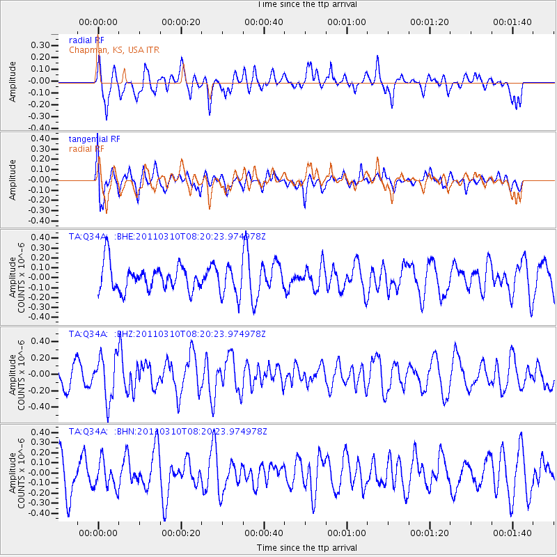
Q34A Chapman, KS, USA - Earthquake Result Viewer
*The percent match for this event was below the threshold and hence no stack was calculated.
| Earthquake location: |
Off East Coast Of Honshu, Japan |
| Earthquake latitude/longitude: |
38.6/143.3 |
| Earthquake time(UTC): |
2011/03/10 (069) 08:08:20 GMT |
| Earthquake Depth: |
17 km |
| Earthquake Magnitude: |
5.7 MW, 5.3 MS, 5.4 MB, 5.6 MW |
| Earthquake Catalog/Contributor: |
WHDF/NEIC |
|
| Network: |
TA USArray Transportable Network (new EarthScope stations) |
| Station: |
Q34A Chapman, KS, USA |
| Lat/Lon: |
38.92 N/96.94 W |
| Elevation: |
378 m |
|
| Distance: |
85.1 deg |
| Az: |
42.801 deg |
| Baz: |
316.963 deg |
| Ray Param: |
$rayparam |
*The percent match for this event was below the threshold and hence was not used in the summary stack. |
|
| Radial Match: |
55.565525 % |
| Radial Bump: |
400 |
| Transverse Match: |
55.31286 % |
| Transverse Bump: |
400 |
| SOD ConfigId: |
356183 |
| Insert Time: |
2011-08-09 17:05:11.128 +0000 |
| GWidth: |
2.5 |
| Max Bumps: |
400 |
| Tol: |
0.001 |
|
Signal To Noise
| Channel | StoN | STA | LTA |
| TA:Q34A: :BHZ:20110310T08:20:23.974978Z | 2.4295547 | 2.7378277E-7 | 1.12688454E-7 |
| TA:Q34A: :BHN:20110310T08:20:23.974978Z | 0.9701242 | 1.3300286E-7 | 1.370988E-7 |
| TA:Q34A: :BHE:20110310T08:20:23.974978Z | 1.1857378 | 1.540584E-7 | 1.2992619E-7 |
| Arrivals |
| Ps | |
| PpPs | |
| PsPs/PpSs | |


