You are here: Home > Network List > TA - USArray Transportable Network (new EarthScope stations) Stations List
> Station 243A Waterproof, LA, USA > Earthquake Result Viewer
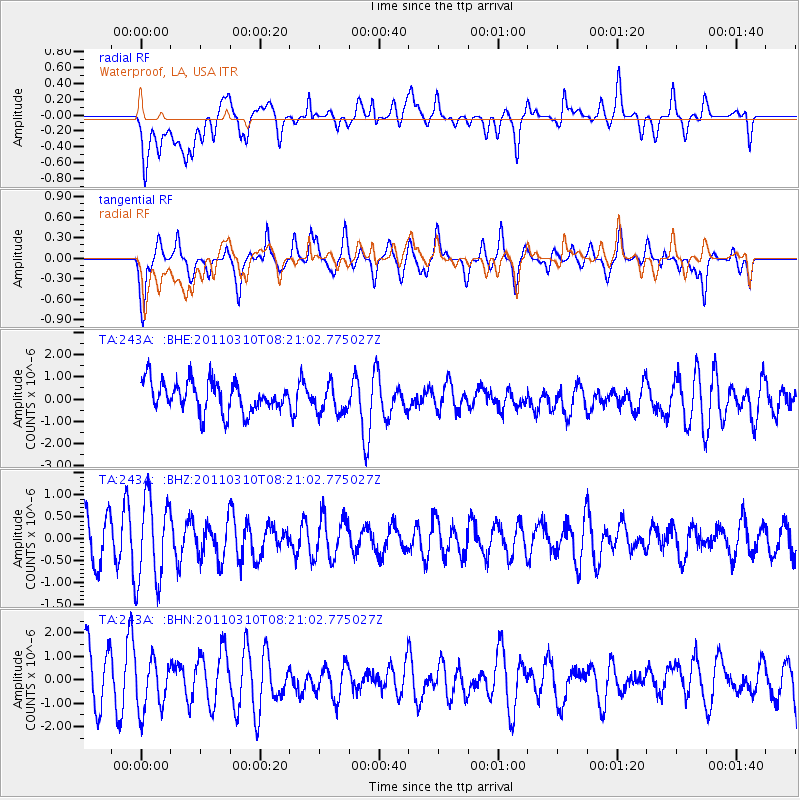
243A Waterproof, LA, USA - Earthquake Result Viewer
*The percent match for this event was below the threshold and hence no stack was calculated.
| Earthquake location: |
Off East Coast Of Honshu, Japan |
| Earthquake latitude/longitude: |
38.6/143.3 |
| Earthquake time(UTC): |
2011/03/10 (069) 08:08:20 GMT |
| Earthquake Depth: |
17 km |
| Earthquake Magnitude: |
5.7 MW, 5.3 MS, 5.4 MB, 5.6 MW |
| Earthquake Catalog/Contributor: |
WHDF/NEIC |
|
| Network: |
TA USArray Transportable Network (new EarthScope stations) |
| Station: |
243A Waterproof, LA, USA |
| Lat/Lon: |
31.88 N/91.48 W |
| Elevation: |
2.0 m |
|
| Distance: |
93.3 deg |
| Az: |
44.103 deg |
| Baz: |
320.136 deg |
| Ray Param: |
$rayparam |
*The percent match for this event was below the threshold and hence was not used in the summary stack. |
|
| Radial Match: |
47.952667 % |
| Radial Bump: |
400 |
| Transverse Match: |
54.812717 % |
| Transverse Bump: |
384 |
| SOD ConfigId: |
356183 |
| Insert Time: |
2011-08-09 17:18:07.748 +0000 |
| GWidth: |
2.5 |
| Max Bumps: |
400 |
| Tol: |
0.001 |
|
Signal To Noise
| Channel | StoN | STA | LTA |
| TA:243A: :BHZ:20110310T08:21:02.775027Z | 1.9950242 | 9.664029E-7 | 4.844066E-7 |
| TA:243A: :BHN:20110310T08:21:02.775027Z | 1.0181476 | 1.0600086E-6 | 1.0411148E-6 |
| TA:243A: :BHE:20110310T08:21:02.775027Z | 0.98137045 | 6.723237E-7 | 6.8508655E-7 |
| Arrivals |
| Ps | |
| PpPs | |
| PsPs/PpSs | |


