You are here: Home > Network List > US - United States National Seismic Network Stations List
> Station HAWA Hanford, Washington, USA > Earthquake Result Viewer
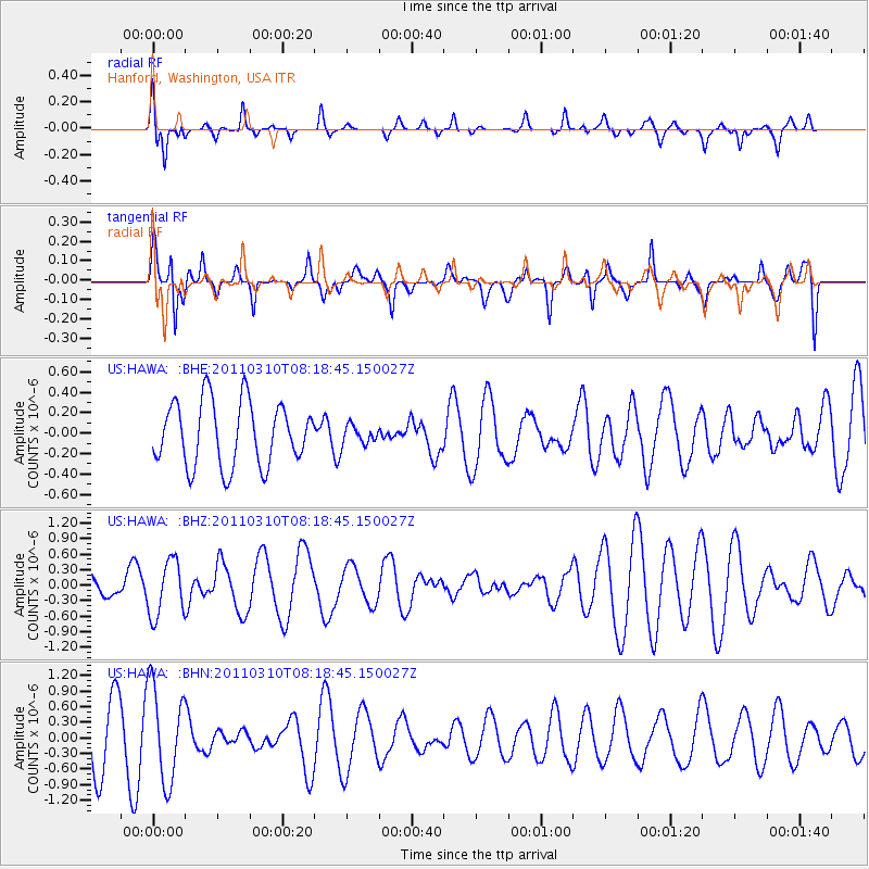
HAWA Hanford, Washington, USA - Earthquake Result Viewer
*The percent match for this event was below the threshold and hence no stack was calculated.
| Earthquake location: |
Off East Coast Of Honshu, Japan |
| Earthquake latitude/longitude: |
38.6/143.3 |
| Earthquake time(UTC): |
2011/03/10 (069) 08:08:20 GMT |
| Earthquake Depth: |
17 km |
| Earthquake Magnitude: |
5.7 MW, 5.3 MS, 5.4 MB, 5.6 MW |
| Earthquake Catalog/Contributor: |
WHDF/NEIC |
|
| Network: |
US United States National Seismic Network |
| Station: |
HAWA Hanford, Washington, USA |
| Lat/Lon: |
46.39 N/119.53 W |
| Elevation: |
364 m |
|
| Distance: |
67.6 deg |
| Az: |
47.949 deg |
| Baz: |
302.797 deg |
| Ray Param: |
$rayparam |
*The percent match for this event was below the threshold and hence was not used in the summary stack. |
|
| Radial Match: |
61.431915 % |
| Radial Bump: |
338 |
| Transverse Match: |
41.183662 % |
| Transverse Bump: |
308 |
| SOD ConfigId: |
356183 |
| Insert Time: |
2011-08-09 17:19:58.282 +0000 |
| GWidth: |
2.5 |
| Max Bumps: |
400 |
| Tol: |
0.001 |
|
Signal To Noise
| Channel | StoN | STA | LTA |
| US:HAWA: :BHZ:20110310T08:18:45.150027Z | 1.503559 | 5.359543E-7 | 3.5645715E-7 |
| US:HAWA: :BHN:20110310T08:18:45.150027Z | 1.8490137 | 9.138043E-7 | 4.9421175E-7 |
| US:HAWA: :BHE:20110310T08:18:45.150027Z | 0.28447986 | 8.843687E-8 | 3.1087214E-7 |
| Arrivals |
| Ps | |
| PpPs | |
| PsPs/PpSs | |


