You are here: Home > Network List > AK - Alaska Regional Network Stations List
> Station KTH Kantishna Hills > Earthquake Result Viewer
KTH Kantishna Hills - Earthquake Result Viewer
| Earthquake location: |
Off East Coast Of Honshu, Japan |
| Earthquake latitude/longitude: |
38.0/143.2 |
| Earthquake time(UTC): |
2011/03/11 (070) 06:46:31 GMT |
| Earthquake Depth: |
31 km |
| Earthquake Magnitude: |
5.9 MB |
| Earthquake Catalog/Contributor: |
WHDF/NEIC |
|
| Network: |
AK Alaska Regional Network |
| Station: |
KTH Kantishna Hills |
| Lat/Lon: |
63.55 N/150.92 W |
| Elevation: |
1172 m |
|
| Distance: |
46.2 deg |
| Az: |
34.494 deg |
| Baz: |
268.798 deg |
| Ray Param: |
0.07075676 |
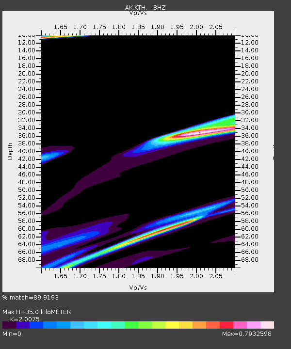
| Estimated Moho Depth: |
35.0 km |
| Estimated Crust Vp/Vs: |
2.01 |
| Assumed Crust Vp: |
6.438 km/s |
| Estimated Crust Vs: |
3.207 km/s |
| Estimated Crust Poisson's Ratio: |
0.33 |
|
| Radial Match: |
89.9193 % |
| Radial Bump: |
368 |
| Transverse Match: |
67.54843 % |
| Transverse Bump: |
400 |
| SOD ConfigId: |
356183 |
| Insert Time: |
2011-08-10 19:05:22.402 +0000 |
| GWidth: |
2.5 |
| Max Bumps: |
400 |
| Tol: |
0.001 |
|

Signal To Noise
| Channel | StoN | STA | LTA |
| AK:KTH: :BHZ:20110311T06:54:22.34799Z | 1.7775317 | 8.9034926E-5 | 5.008908E-5 |
| AK:KTH: :BHN:20110311T06:54:22.34799Z | 0.7307883 | 5.2258987E-5 | 7.151043E-5 |
| AK:KTH: :BHE:20110311T06:54:22.34799Z | 2.2082026 | 1.1781462E-4 | 5.3353175E-5 |
| Arrivals |
| Ps | 5.8 SECOND |
| PpPs | 15 SECOND |
| PsPs/PpSs | 21 SECOND |


